Just short of Sausthorpe, with its landmark church beside the A158, set on a sandstone plateau forty metres asl is the River Lymn. Sadly after having cut its own natural contorted course through the soft clay down the length of the dale the final last few hundred metres of its main tributary, Snipe Dales Beck, have been brutally redirected to flow along the side of the road that leads to Sausthorpe Bridge, crossing the Lymn where the beck and the river meet. (See the post discussing the beck’s geological profile and The River Lymn & Its Tributaries posts.)
Langton Edge 391701 – 401711

Heading northeast from Sausthorpe, passing over the OS grid square that contains Sausthorpe and the attractive grounds of its hall, the profile illustrated above follows the line which starts by Langton Beck, passes by Langton village, and finally climbs the steep and wooded Langton Edge. This line keeps close company with the road that passes through the village, which climbs the scarp slope just to the north. Langton is the last village set on the sandstone, but from here there are half a dozen different types of strata before the land levels out on the chalk plateau at ninety metres asl. The character of the land upon the chalk changes from having been sheltered and wooded to dry open arable fields on gently rolling hills. (See Langon Old Road post.)
Bag Enderby 340710 – 350720

Five kilometres northwest of Sausthorpe, Bag Enderby stands on the same sandstone plateau just ten metres higher than Sausthorpe. It too overlooks the River Lymn, but here the river is confined in a trench-like valley just a few hundred metres in width. On the far side, opposite Bag Enderby’s medieval church, is a small sandstone-topped hill. Beyond it, the land dips before gently rising to another sandstone plateau on which stands the tiny hamlet of Stainsby. (See Somersby & Bag Enderby post.)
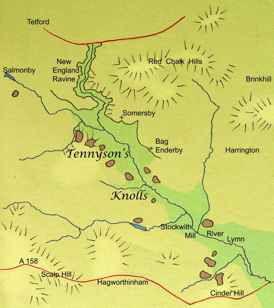
The small isolated sandstone hill just referred to may be a subtle feature in the landscape, but it is just one of a good number of similar hills, never much over sixty metres asl, which overlook the River Lymn stretching from Salmonby southeast as far as the A158. The most prominent, however, are those that lie directly opposite Somersby and are immortalised in Tennyson’s most admired poem, In Memoriam AHH. Here he remembers one benign summer’s evening looking across from the garden of the rectory, where he spent the majority of his first twenty-eight years, and describes it thus –
While now we sang old songs that peal’d
From knoll to knoll, where, couch’d at ease,
The white kine glimmer’d, and the trees
Laid their dark arms about the field.
These knolls, lined on either side of the River Lymn, are a legacy of the Last Glacial Maximum, when, for a time, the River Lymn’s power was increased manyfold by the glacial meltwater from several blocked dales further north trying to escape the Wolds by a more southerly route. This torrent cut the New England Ravine just upstream from Somersby and the trench-like valley that continues on to Stockwith Mill, where the force of the water was finally dissipated when entering a temporary lake dammed by another glacier. (See New England Ravine & Warden Hill post and The River Lymn and its Tributaries post.)

The white house is the Tennyson Rectory, with a garden that stretches down to the River Lymn.
During these periglacial conditions, permafrost gripped the land, but when it finally thawed for a time, the land would have been unstable, causing episodes of solifluction along steeper slopes. This would have been the case on the steep-sided trench along which a more benign River Lymn now flows. Even subtle dips in the land, which were the most saturated when thawed, would have slid into the valley bottom, leaving the intervening high points as the knolls Tennyson observed thousands of years later.
The River Lymn between the Tennyson villages of Somersby and Tetford.
The small streams that form the River Lymn run down from the hills west of Tetford. They pass through the village as a fast-flowing stream, which at this stage is the epitome of Tennyson’s brook. Particularly just past Tetford watermill, it babbles over rocks and roots as it hurries through the village, but instead of carrying on east along a broad valley toward South Ormsby, it takes a sharp right and enters the New England Ravine. 20,000 years ago, as the main valley was blocked by ice. This then caused it to flood and the river to spill over a low ridge into the valley to the south, and with the force of the meltwater from the glacier, it cut a steep-sided valley through the sandstone strata down to the clay below. Beyond the ridge, this surge of water also gouged out a trench 500 metres wide in the soft clay all the way to Stockwith Mill before spilling out into another temporary glacial lake partly surrounding today’s village of Sausthorpe.

Looking down into the New England Ravine. It was near here that Tennyson first went to school.
