The head waters of the River Lymn come together to form a sizeable stream about two kilometres west of Tetford. These original trickles run down from the surrounding hills that reach a height of 140 metres asl and meet at a height of just 60 metres asl. The dale quickly becomes broad as it opens out to the east but suddenly narrows again as it reaches the South Ormsby estate at 45 metres asl. The young river however chooses to flow southeast and enter a long tree filled ravine running generally north south just halfway along the upper dale.

So why does it not continue to flow in the expected general easterly direction like most other streams in the Lincolnshire Wolds? The first clue to this is the height of the dale as it enters the South Ormsby estate because after the same distance the river is 8 metres lower as it enters Lower Lymndale just south of the village of Somersby.
What is also unusual about the upper dale is that there is only one settlement in the whole valley despite being 5 kilometres long and up to 2 kilometres wide and in an area where parishes are usually small and numerous. This is the large village of Tetford at the west end of the dale and includes the hamlet of Little London just north of Tetford church. Even the roads and farms in the dale avoid the valley floor, which is simply called the Moor but this bleak name hides an intriguing set of events which took place here thousands of years ago when the Wolds were a very different place.
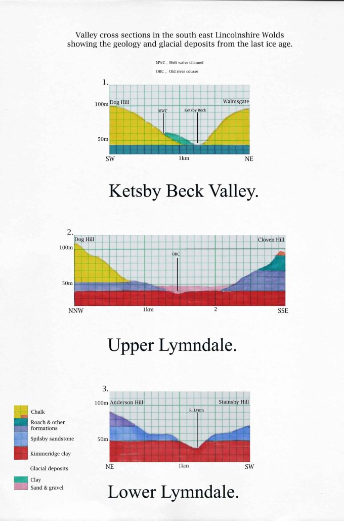
When 20,000 years ago a large glacier from Scotland pushed right up against the Lincolnshire Wolds to a present day height of 100 metres asl it blocked all streams following east which were then forced to find new routes off the high ground. From a distance of seven kilometres north all waters were funnelled south through narrow valleys along the edge of the glacier cutting through a series of chalk ridges until the water spilled out into the wide valley of Upper Lymndale. These little valleys cut by the melt water are often called spillways.

During the summer when the volume was at its maximum most of this water would be from melting ice and full of sediment which the glacier had bulldozed ahead of it on its way south. During the last glacial maximum the volume of water would be more than the total amount of water flowing today from all the rivers of the Lincolnshire Wolds. Forced along the many spillways this mix of water and sediment had a scouring effect sufficient to erode down to a depth of twenty metres in just a number of years at Deepdale, just four kilometres north of Tetford. Further to the north remain many more similar dry narrow valleys aligned perpendicular to the normal west east drainage pattern of the Wolds all the way up to a few kilometres east of Caistor.
From Deepdale the melt water was funnelled along the valley of Ketsby beck until it found a point along Worlaby Rigg which was low enough to allow it to spill into Upper Lymndale. This point was at the western edge of the South Ormsby estate parkland but later as the ice slowly retreated it found several lower points along the ridge where it could escape making the ridge just north of South Ormsby quite fretted as can be seen from the Bluestone Heath Road.

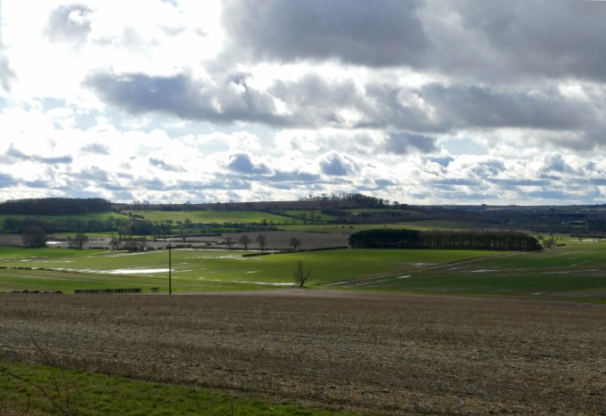
When the melt water entered Upper Lymndale blocked by ice and a broad terminal moraine stretching right across the estate it slowed and spread across the broad dale. The view in the image taken from the top of Oester Dale looks across the whole estate and where the wooded park now stands during the last glacial maximum the head of the glacier would have been in roughly the same position but standing a lot higher. In fact it would have been pushing up against the chalk ridge in the background. The ridge is 100 metres asl and the glacier would have been almost as high. It would have completely filled the dale and forced meltwater to flow west and upstream causing it to spread across the broad valley as a shallow lake. This image was taken in early June and 20,000 years ago at this time of year the glacier would be melting rapidly along its edge so standing at this spot then not only would you have had a dramatic view of the glacier but you would have probably been able to hear the torrents of water rushing through Deepdale just to the north. The cattle in the middle distance would have more likely have been musk oxen or even mammoths!
On entering the broad dale the melt water slowed with the sediment suspended in the water settling out on to the floor of the dale. There was so much water and sediment that both spread right across the dale as a wide shallow lake. The water finally found a way to continue its journey through a gap in a sandstone ridge at Meridian gill close to modern day Tetford. The sediment on the other hand was mostly left behind and eventually built up to form a large area of sand and gravel up to a depth of ten metres. This has made the geology of the upper dale quite different from the lower dale. With the valley floor covered in layers of drift it is only really the chalk strata, which is left exposed with the many other types of strata that can be seen in the lower dale covered over.
This area is now known as the Moor and even today roads, houses and streams avoid it with one exception. The Romans built a road from Lincoln to the coast near Skegness that once crossed it. Even with the Roman’s dedication to straight lines this was an odd route to choose when there was an easier route to the coast from Lincoln along the present day A158. Soon after the Roman legions left their road was abandoned. Only short sections continued in use by locals either side of Tetford. (See Bluestone Heath Road Blog.)

With a barrier of glacial clay further east at the end of the dale any rainfall on the Moor can only seep down through the sand and gravel and find its way underneath the glacial deposits until it is able to re-emerge some six kilometres further east at the tiny hamlet of Belleau. As its name implies this is the location of a copious spring of crystal clear water that rushes down into the nearby Great Eau finally allowing this modest beck to live up to its grand name. In medieval times this river soon became a significant enough to have a large motte and bailey built beside it at Toot Hill. At the time the Norman castle was built the river was probably navigable up to this point and where it reached the sea was the port of Saltfleet, which in its medieval heyday rivalled Grimsby and Wainfleet.
Yet despite this the Great Eau might have been greater if the upper reaches of the River Lymn had continued to flow east as they had done before the last ice age but then it would have also been a shorter river. This is because during the last interglacial the coastline encroached right up to the edge of the Wolds with all land that is now east of the high ground to the present coastline being made up of glacial or post glacial deposits.