For a main road the drive along the A16 down Dalby Hill to Partney is one of the most pleasant in the Wolds. You pass through Dalby, which is mostly hidden by tall trees, and also hides one of the most pleasant walks in these parts. This takes you through the Dalby Estate all the way to Skendleby where the Blacksmith Arms is waiting to welcome you. Dalby Hall is set magnificently on a hill protected by a belt of trees set on a ridge to the north and overlooks a small lake and a diminutive church to the south. A quiet lane from Skendleby climbs the ridge to the north and offers good views while taking you back to Dalby. The final part cuts diagonally through the estate along a bridleway to return to the A16 200 metres short of where you started.

It is remarkable that we know two inhabitants of Partney from the late seventh century. They were Deda and Ealdwine, both abbots of an early Anglian monastery built here, who were known to the Venerable Bede (673-735) living far away in Jarrow by the River Tyne. Also thanks to Bede ‘s Ecclesiastical History of the English People we know that Ealdwine had a brother Aethelwine who was Bishop of Lindsey for twelve years and a sister Aethelhild who was abbess of a minster close to Partney.
They are also the first named individuals living in the Wolds but were not necessarily born there because it was normal in these times that high clerical positions were almost exclusively taken by people of aristocratic birth or even royal lineage. Partney was probably a cell of Bardney Abbey, which definitely had connections to Mercian Royalty and of which more is known. Unfortunately there is little known about Partney’s two religious foundations including their exact location but the fact that a brother and sister were in charge of them tends to suggest they had a strong connection with the area.
At this time Lindsey was a sub kingdom of Mercia who had wrested it from the Northumbria after the great battle of the Trent in 679 AD. Bede also tell’s us that about fifty years earlier Gregory’s missionary Paulinus converted Blaecca, Praefectus of Lincoln to Christianity. This nugget of information tells us that Blaecca was head of the province of Lindsey and province is thought by scholars to refer to a minor kingdom. Lindsey like many Anglo Saxon emergent kingdoms does has a royal genealogy but these are part mythological with no other written references to most of the kings listed. The bishops of Lindsey on the other hand are well documented because they were influential in Mercian politics at the height of its powers right through the eighth century. They start with Bishop Eadhaed (678-679) and end with Bishop Eadberht in 875(?). But it was Bishop Aethelwine the second on the list who was the first to have a lengthy tenure. It is also possible that he and his brother and sister living in Partney were descendants of Blaecca who was himself likely to be of a lineage that descended from kings when Lindsey had been a fully independent kingdom.
The Tribal Hidage from the late seventh century singles out Lindsey as a unit of 7000 hides equal to Essex and Sussex, which were previously small kingdoms, and suggests Lindsey once had equal status for a period sometime after the Roman legions left and Christianity arrived. In contrast it is likely that Lincolnshire did not become a county until after the Norman Conquest. This could help explain why the difference between northern and southern dialects in the county is so great especially with the land around the Wash having closer ties with East Anglia during the time of the Danelaw.
Partney did not regain its abbey after the conquest like Bardney and only briefly had a hospital of St Mary Magdalene run by monks between the twelfth and fourteenth centuries. Excavations during the building of the recent A16 village bypass unearthed a large medieval graveyard that could be associated with this foundation as the skeletons were predominately adult males. This was found to the west of the village just over the stream, which is crossed appropriately by Monks Lane.
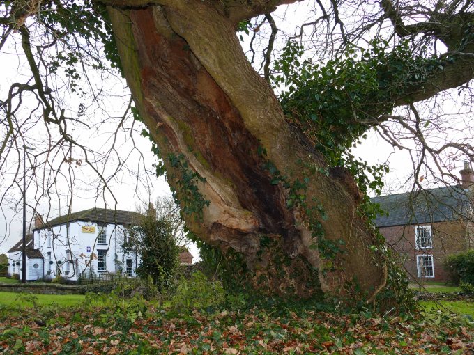
The east end of this unmetalled lane starts close to the church which has a high tower and tall clerestory standing impressively on a mound surrounded by handsome Georgian houses with the popular Red Lion Inn close by. Unusually in front of the south door of the church are three oak trees with the usual yews restricted to the east end of the church. One oak is only young, the second is a mature tree planted in 1819 but the third is ancient. In fact the north side of the trunk is completely rotted and the tree leans at a precarious angle in this direction. In contrast the other side of this venerable oak looks healthy with a long branch extending from it acting as a counter balance to the leaning trunk. However a little human intervention to stabilise the tree would help see this venerable old specimen last for another century. White’s 1892 gazetteer mentions “In the churchyard is a large venerable oak, probably not much less than a thousand years old, but now fast falling to decay.” With this oak being such a great age and Partney’s own ancient associations with the Venerable Bede it would be good to name the tree after him. Thanks to the recent bypass all this can now be appreciated in tranquil surroundings.

Although Spilsby’s church also has an impressively tall oak next to its tower it is inside that the real treasures lie and explain the town’s rise at the expense of its neighbour. There is a chapel in the northeast corner of the building crammed with decorative medieval tombs without equal in Lindsey. These are nearly all members of the wealthy and influential Willoughby family starting with the first baron Sir Robert Willoughby. It was he who changed the fortunes of the town by relocating it away from the river onto its present ridge top site and obtained a charter in 1302 for a regular Monday market and an annual fair to be held in Spilsby. He also founded a college of priests for whom he built a chapel.
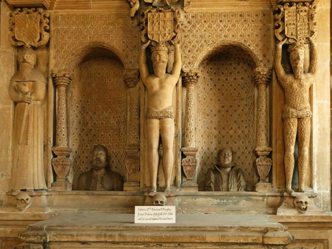
The church also dates from the beginning of the fourteenth century but was altered and extended over the next century. In the Willoughby Chapel are memorials from the second to fifth barons roughly coinciding with the time of the Hundred Years War in which both the second and third barons, and both called John, played a prominent part. John the elder fought at the battle of Crecy and his son at Poitiers. John, the third Baron Willoughby, lived exactly half way between the lives of the first abbots of Partney and our lives today. One wall of the chapel is taken over by an unusual monument from the sixteenth century dedicated to a later branch of the family.

Tennyson’s connection to Spilsby is through his wife, Emily, whose mother, Sarah, was sister to the famous Arctic explorer Sir John Franklin. From middling stock like Alfred’s family after an active naval career during the Napoleonic Wars, followed by time as Lieutenant Governor of Van Diemen’s Land he became best known as an Arctic explorer in search of the Northwest Passage. After several expeditions he final attempt ended in disaster with the whole crew lost and it is only in recent years that enough evidence has been discovered to finally piece together what went so wrong to a well equipped expedition led by such a seasoned explorer. One could say that similar to Tennyson Franklin has suffered from the modern world’s unsympathetic view of the motivations and ambitions of the outstanding characters of the Victorian Era.
The A 16 is a convenient eastern boundary for Lower Lymndale. It crosses the river close to Partney Mill. It is now obsolete but the mill’s surviving pond does serves as the first main abstraction point along the river. This diminishes the flow for a while until it picks up a couple more tributaries before turning south to cut through the sandstone ridge east of Spilsby. It has to be said that it is fortunate in these resource hungry times that upstream from Partney mill abstraction from the river or the hills surrounding it is presently only minor but with the rate that houses that are being built in towns around the Wolds this could change.
The reason for the sudden change in the rivers direction, which actually takes it out of the main valley, is the barrier of the Partney moraine from the last glacial maximum. This and its attendant glacier blocked the whole dale 20,000 years ago and even today when driving west along the A 158, by passing Partney, the road rises over the moraine and then dips down to the river but not before allowing a brief preview of the lower dale spread out before you. The effect would have been greater if the road builders had not cut through the top of moraine.

The barrier that the moraine and ice created was enough to create Lake Lymn, which quickly flooded the wide valley and forced the river to find an outlet to the south which it still uses. (See Halton Holgate Blog.) The size of the lake is open to debate but there is a smaller overflow channel a kilometre west of the river’s present course that would give the lake a maximum height of 40m above present sea level allowing it to spread up the dale as far as Somersby. Straw (1979) identified “lacustrine clays and sands”at the western end of Brinkhill gap at 47metres asl. which could be associated with Lake Lymn or a smaller glacial lake centred on the village of Brinkhill. (See Upper Lymndale Blog.)
If glacial Lake Lymn did reach this height then the outflow would have to be further west along the Spilsby sandstone ridge in the vicinity of Hundleby. The very latest research (Nov. 2018) by the Geologists Association speculates a possible maximum height for the lake of 75 m. asl. but it is probable that the evidence for this figure found on Harrington Hill and Straw’s findings just a few hundred metres to the north west when accurate dates are confirmed will belong to the previous Wolstonian/Tottenhill glaciation (MIS 6). These findings however could explain the Belchford gap, the deepening of the Waring valley and the capture of its source spring from the River Lymn during a phase when it acted as a western overflow channel for an earlier version of a glacial Lake Lymn over 100,000 years ago.
What is coming to light from this most recent research is that the last glacial maximum, when glaciers reached north Norfolk and created the Stickney moraine north of Boston, was due to a glacial surge partly due to a lot of water present within the glacier. This also made it unstable causing it to soon to collapse leaving massive chunks of stagnant ice as the glacier retreated to a new limit which stretched along the eastern edge of the Wolds in a curve from South Killingholme south to Hogsthorpe north of Ingoldmells. This means that although the effect the last glacial maximum on Lymndale was extensive it was only relatively brief with the time possibly being measured only in decades rather than centuries. (See Walmsgate Blog.)
