When at school I had to learn a hymn that started “There is a green hill far away”. The only green hills I was interested in back then were the Wolds, which I visited at weekends with friends on our bikes looking for steep hills and clear streams. The green hill I am standing on today (TF 388734) is two kilometres west of Ulceby Cross and seemed far away then with only pedal power available. Today however the second line of the hymn “Without a city wall” resonates more loudly as the hill is remarkable only for it lack of features.
This dome of chalk is completely bare except for a sparse hedge and a green haze of winter crops and does not even have a name. Yet nearly two thousand years ago it was crossed by a Roman road, close to the line of a hedge, which is now its only feature. There is no sign now that the road, which ran east from Lincoln to the coast, ever passed this way. It cut across the Wolds in a straight line and its route can still be traced west from the top of Flint Hill to Lincoln and southeast from just west of Ulceby down to Burgh le Marsh. Though this last section follows the much more ancient Bluestone Heath Road in a straight line along the final chalk ridge of the Wolds.
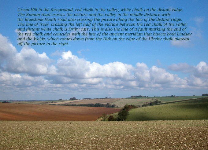
The rest of this ancient ridgeway crosses the Wolds via Calceby and then along a route that sensibly remains high and dry following the chalk ridge opposite Green Hill. The Roman Road instead of finding a similar ridge route, for example that of the modern A158 through the Roman town of Horncastle to the coast, made a beeline for the Iron Age centre 600 metres west of Ulceby Cross, which was then made a Roman centre. When they left, nearly 400 years later. the road and their centre appear to have soon been abandoned and Green Hill eventually became green and featureless again. Worth visiting only for viewing sunsets in summer.

Although there was some evidence of an Iron Age centre on the chalk plateau near Ulceby Cross no fortified settlements have been found on the Wolds. In most other parts of Britain an isolated hill like Green Hill or other suitable eminences in the area would have been prime candidates for Iron Age hill forts but it seems in this part of England there was no call for them, which suggests a more co-operative approach to land and resources than elsewhere on the island.
Other more ancient landmarks however such as round barrows and long barrows are plentiful, especially the latter on the chalk plateau just to the southeast of Green Hill. Despite being as numerous as long barrows around Stone Henge they are not easy to spot today. However they could be the reason for the Romans direct route to the prehistoric centre, which once may have had considerable strategic and symbolic significance possibly going back thousands of years. (See Bluestone Heath Road Blog.)
Looking in the opposite direction to the west across this wide gap in the Wolds it strikes one that there should be a sizeable river flowing through such a wide valley. This missing river is the Lymn whose source is in the hills to the west but was rerouted south during the last ice age.
So there is already a theme starting to develop here. A diverted river, an empty valley, lost barrows, a missing Roman road and an absence of Iron Age hill forts. Stood atop this bare hill with its broad vista there is little to catch the eye. In the distance to the east the busy A16 crosses Driby Top with a profile of moving lorries crossing the horizon and a little to the north there is a gap in the hills which extends the view across the wind turbine infested marsh to the coast but in the other directions there are just fields, woods and hills plus the odd farm. This is probably how it has been since each parish became enclosed and before that there would have been just less hedges and more sheep.

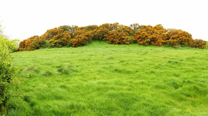
200 years ago at the time of the first Ordnance Survey, when the famous poet Alfred Lord Tennyson was just a lad living in the next dale, there were tracks leading over the hill connecting the now cul de sac village of Driby with its neighbouring villages. From this first accurate survey we know from the frequent mention of the word furze, an old word for gorse, that in Spring the surrounding hills, and possibly Green Hill itself, would have been yellow with blazes of gorse. This also indicates that there would have been more pasture than today. This would have been classic chalk grassland grazed possibly by Lincolnshire Longwool sheep and this would have created a rich diversity of flora and also insects. Summer migrant birds would feed on these and nest in the gorse so that this now silent, empty hill would then have been full of life. (See A Land of Flowery Squares Blog.)
Green Hill is also on the southern boundary of the South Ormsby estate. This stretches across several parishes and has done so for several centuries. At its heart is the largest area of woodland pasture remaining in the southern Wolds hiding the eighteenth century hall and a whole host of other creatures have their home there as this is recognised as one of the most species rich temperate ecosystems. The rest of the estate is managed as an efficient modern farm although there is more woodland remaining than in other parts of the Wolds. Also rights of way across the estate have managed to remain largely intact which can not be said for the land to the north and south. The surrounding villages connected, once by the paths and tracks, are now diminished or even deserted. (See Calceby & the Domesday Book Blog.)
At Calceby there is a cluster of ruined walls on a hill that was once the parish church. This and a farm is all that is left of the deserted village. Earthworks and a disused church at Driby indicate that this was once a busier village and remains of a moat near Brinkhill suggest this was once a place of importance. The only road that crosses the valley connects Brinkhill to South Ormsby before the valley widens further west to an empty area just labelled moor and fen. This is a legacy of the last glacial maximum, which diverted the River Lymn south by blocking the valley with glacial deposits causing it to be poorly drained so that the Romans where the only ones to attempt building a road across it. (See Upper Lymndale Blog.)

There appears to have been more going on back in Roman times and evidence from the Domesday Book confirms that things were busier a thousand years ago. The land was filled with villages with Danish name endings such as by and thorpe, occupied by people with Danish personal names who used Scandinavian words to describe the landscape for this was the most Danish part of the whole Danelaw.
Now it is very peaceful here with few sounds. Until this century this would not have been a big selling point but now peace is at a premium in this overcrowded island and people are prepared to go to lengths searching for it; often only to find on arrival a lot of other people that had the same idea. If there is exceptional scenery, a visitor centre or other amenities the crowds are almost guaranteed on a nice weekend. So it is reassuring to continue what is not to be found in this part of the Lincolnshire Wolds. Unlike the Wolds further north there are no pylons although there is a watching brief on this with so many wind turbines planned for offshore to generate electricity for inland cities it will need to be transferred to them somehow. Again unlike in many other parts of Lincolnshire, well known as “Bomber County”, there are no nearby abandoned airfields, which often end up as convenient places to locate light industry or some form of factory farming. The complete absence of golf courses is also reassuring together with the total lack of hotels, self catering lodges or caravans parks. There is plenty of accommodation available but you need to look hard to find it because so far they are mostly converted traditional buildings.
Further back in time this area somehow seemed blessed by having avoided battles, castles and monasteries although these can be found all around the edge of the Wolds as can tall windmills and some magnificent churches principally St. James Louth which along with Lincoln cathedral and Boston Stump can be spotted by the keen eyed from many hilltop locations. Wolds churches with a few exceptions are usually small and built of friable local stone though some, like St. Peter’s Lusby, are very ancient.

To define the area a little more precisely for a thousand years, going back to the Danelaw, this was a region of jurisdiction called Hill Wapentake and still remains the most accurate way to define it. Today it also happens to be one of the most unspoilt and attractive parts of the Wolds. It starts immediately west of Green Hill and stretches across many other hills to Greetham close to the main coast road or A158. Apart from this road along its southern border the wapentake contains no other main roads, it never had a railway and was too hilly for canals. With the exception of South Ormsby, which has been little altered in 400 years, there are no grand estates. (See South Ormsby Estate Blog.)

It still remains most well known for as being the birthplace of the country’s longest surviving poet laureate Alfred Lord Tennyson. His formative years were spent growing up in the little hidden village of Somersby right in the heart of Hill Wapentake. The area is actually better known as Tennyson Country but this is less precise. However famous he was in Victorian times it has to said he is a lot less popular now especially in his home country but selective reading of his poetry can give us an insight into how this area looked 200 years ago. (See Somersy & Bag Enderby Blog.)
This is particularly fortunate because Tennyson was born in the heart of some of the most interesting lowland scenery in the country. The varied geology not conducive to modern farming methods, together with being fairly remote from any large towns or cities has left the area largely unspoilt and undiscovered. To get here from Green Hill or Ulceby Cross to his birth place requires a delightful drive along erratically winding empty lanes, over hill and down dale and through woods and hidden wooded hamlets.

The River Lymn flows passed close by his family home, which was the rectory and his father, the Reverend Doctor George Clayton Tennyson, ministered the twin villages of Somersby and Bag Enderby. There are hills of chalk to the north and east and sandstone in the south and west but most characteristic is the line of hummocky hills in between made largely from a hard band of rock called Roach Stone. (Roach Ridge Views Blog.) Out of, around and between these hills meanders the River Lymn and its many tributaries. As seen in the neighbouring or upper dale during the last glacial maximum copious amounts of water was forced into the lower dale giving the river greater erosive power. The use of the word dale in place of valley is appropriate in that both physically and historically this area resembles features that are usually associated with places much further north. (See Upper Lymndale and New England Ravine & Warden Hill Blogs.)

The river was able to cut through rocks down to a layer of soft impervious clay, which made the valley bottoms very wet. Even today they are filled with wetland woods known as carrs forming useful wildlife corridors but mostly remain unconnected to each other. The River Lymn as far as Stockwith Mill is still, unlike many modern rivers, allowed to meander freely between columns of tilting alders. With extra planting to allow the carr corridors to connect, the restoration of lost meadows, and allowing streams to flow naturally could create an attractive living Lymndale landscape conducive to wildlife and humans alike. It would also go someway to help avoid a repeat of the River Steeping floods experienced in June 2019 as Lymndale is the catchment area for this river. Some re-instating of footpaths too, which were available to Tennyson but now lost, would also help. (See Somersby & Bag Enderby Blog.)

A large inland area rich in wildlife would compliment those wildlife havens that Lincolnshire already has on the coast. Not only is Lymndale not far from either the Saltfleet/Donna Nook and Gibraltar Point National Nature Reserves, but also the Lincolnshire coastal resorts that need to broaden their appeal and lengthen their seasons to remain viable. The woods and streams of Lymndale are most attractive in Spring and Autumn which ties in well with the migratory seasonal peaks and seal pups along the coast. A bleak windy day on the coast could be avoided with the occasional diversion inland to spend time in a sheltered dale observing different woodland and grassland species.
Unlike the view from Green Hill of Upper Lymndale the lower dale is quite different and takes more effort to discover. Whereas the upper dale is wide, flat bottomed and empty Lower Lymndale has different layers to explore. There are the knobbly Roach Hills overlooking a dry sandstone plateau where there are numerous small villages and hidden hamlets connected by winding lanes that in turn overlook the river valley, which has gouged a trench through the sandstone and meanders through wet pasture and woodland well away from human settlements – a natural nature reserve just waiting to be designated as such.

Its tributary valleys with long narrow wet carr woods create a patchwork of mini reserves but the area’s greatest asset is the New England Ravine, which the River Lymn flows through connecting the upper and lower dales. It is larger than all the other carrs and has stands of ancient woodland and is designated as an SSSI. It is a hidden world of wildlife with a greater diversity of flora than anywhere else in the Wolds. It would be wonderful if this reservoir of biodiversity could be allowed to spill over down the dale to create a haven for wildlife similar to that which inspired a young Tennyson growing up here two hundred years ago and was able to wonder along quiet lanes, through dappled woods and among flower filled meadows.

Driving past Tennyson’s Lymndale on the main road to the coast most people who haven’t read Tennysoncountry.com would regard it just as pleasantly undulating but not radically different from much of the landscape they had passed through since entering Lindsey, which on the whole is still largely rural. Indeed most would think it unnecessary to pick out this area of the southern Wolds for special attention. Lincolnshire and the Fens however is nearly all intensively farmed and pressure to produce ever greater yields will only increase in line with population growth. Already vast areas of natural habitat such as fen, marsh, heath and meadow have been lost in recent decades along with many native species associated with these ecosystems. (See All the Land of Flowery Squares Blog.)
Most of Lincolnshire’s large nature reserves are coastal or estuarine with only a few small reserves in the Wolds Area of Outstanding Natural Beauty. In fact what the Wolds is most outstanding for is large rolling fields of barley and rape. An area once mainly permanent pasture has been mostly ploughed up at the cost of many bird and insect species as well as footpaths and ancient monuments.
The success of farming has seen the success of the few over the many and those living in rural communities sometimes find the land around them sterile and difficult to access. This pressure on land in this country means that it is essential to set land aside to be protected in someway. Until now this has been mainly coastal, upland or close to urban centres but there is an equally strong argument to include large intensively farmed areas like Lincolnshire.

In this largely flat part of the country the Wolds is our upland and acts as an aquifer supplying water to most of East Lindsey and the Humber bank. The designation of an Area of Outstanding Natural Beauty is not enough to protect it from the greater intensification of agriculture and coastal urban development which will create ever more demands on a finite resource. As with other upland areas the Lincolnshire Wolds needs greater protection and some areas within it notably Lymndale should be managed more sympathetically to create an island of greater biodiversity in a sea of sterility to try and restore the ecological balance that has been lost in recent decades.
