A brief explanation of the maps and cross sections included in this post.
The map below is designed specifically to highlight the irregular distribution of hills in the area, which is unusual for a chalk escarpment in England and is due to the many different bands of sediment that lie between the top of the escarpment capped with white chalk and the clay valley bottom. I have tried to pick out and name all prominent hills regardless of height or rock type but the clay valley bottom of the River Bain roughly coincides with the 60-metre contour line but does actually continue further north as a narrow band along which the river is contained as far north as Donington.
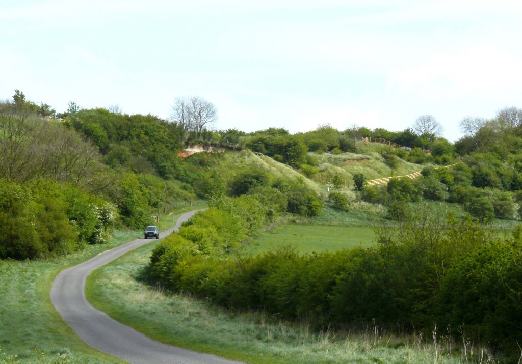
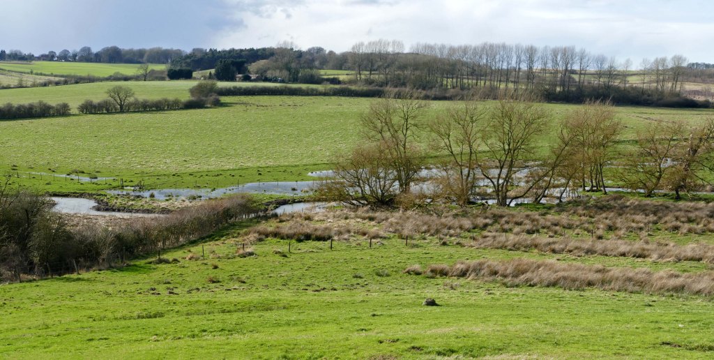
Along this mid-section of the Bain the river still cuts a natural meandering route through the soft clay adding to the diverse nature of the landscape in this area, which is more conducive to wildlife when compared with the straightened river further downstream and the regular open arable field system of the chalk lands away to the north and east. The same is also true regarding the fragmented nature of the landscape immediately east of the Bain due to the series of hills and valleys caused by the regular changes in the underlying geology as you climb up the irregular escarpment towards the Bluestone Heath Road. This is also true but to a lesser extent when heading west from the Bain towards Caistor High Street. These characteristics can clearly be seen in the two geological cross-sections provided at the end of this post.

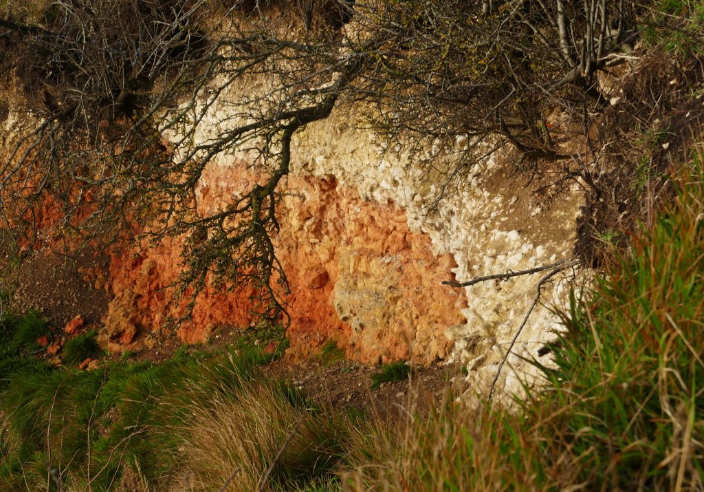
There are two places in the Lincolnshire Wolds where the land rises over 150m above sea level (asl). The highest stretches between Caistor and Tealby, reaching a high point of 168m asl at Wolds Top. This height is made to look more impressive as the land falls away steeply to the west down into the broad clay vale of the River Ancholme. The only other place where the Wolds reach 150m asl are the hills surrounding the wooded hamlet of Stenigot where there is also a rapid transition from chalk wold to clay vale. The best views across the broad valley of the River Bain are to be had from the top of Red Hill where the escarpment projects westward from the wooded Stenigot valley. From this high point, however, the view is not westward but to the south down the Bain Valley. From here framing the left-hand edge of the view is the last few kilometres of the chalk topped escarpment before its veers east at Belchford Hill. Here the land does not fall away immediately down to the River Bain, instead, the older strata emerge as both hard and soft layers to create a much more irregular and interesting landscape. Also, the Bluestone Heath Road south of Cadwell clings to the narrowing chalk ridge with older strata revealed where the land suddenly falls away on both sides of the road. This is because on approaching Belchford Hill the thickness of the chalk has diminished to just five metres in places. The underlying bands of rock are many and varied and include sandstone, limestone, ironstone and clay with Red Hill being the only place where this complex series of strata is fully represented in sequence.
At Red Hill a narrow lane bisects the Lincolnshire Wildlife Trust’s (LWT) nature reserve of the same name. The name comes from the exposure of the thin bed of red chalk overlooking the lane that climbs steeply onto the chalk plateau from the Bain Valley. Beyond the road continues east towards the Bluestone Heath Road at its high point of 150 metres asl on its journey along the brow of the escarpment. The nature reserve on the north side of the lane is steep and made more rugged by once having been a quarry. The rest of the reserve, mostly on the south side of the road, is more gently sloping calcareous grassland noted for its rich mix of wildflowers. Below in the valley, a cluster of villages stand on the low Spilsby Sandstone plateau that overlooks the damp clay valley bottom through which the River Bain flows being joined by several small tributaries along its winding course. At this point in its journey, the river was large enough to power a number of watermills before the industrial revolution but the valley bottom was always too damp for any other type of dwelling. Incidentally, having studied both the Bain Valley and Lymndale in some depth I have come to the conclusion that Tennyson’s poem ‘The Brook” resembles the River Bain more than the River Lymn. (See Tennyson’s The Brook post.)
The Lower Lymn Dale and the Bain Valley though are still very similar in many respects. Both have a clustering of small villages on a sandstone plateau overlooked by higher ridges with a clay valley bottom occupied by a meandering river. Although the geology is basically the same in both Valley and Dale, during the last glacial maximum Lower Lymndale succumbed to a period of inundation of meltwater from the north, via Upper Lymndale, whose erosive power scoured out a trench along Lower Lymndale which today is where a much smaller and sedately meandering River Lymn now flows. This short but rapid period of erosion also affected the river’s tributaries causing them to cut down through the thin sandstone plateau to create many narrow steep sided damp valleys now often occupied by carrs. For a more detailed description see Wet and Wild Carrs and the Geological Profiles of Snipe Dales and Lymndale posts.
In the Bain Valley, which was spared such an episode during the last glacial maximum, such carrs are smaller with the exception of Benniworth Haven. This is a deep mostly hidden valley between Donington and Benniworth containing two small lakes overlooked by some of the best mature beechwoods in the Wolds. The valley floor between the two lakes is uncultivated damp clay with carr vegetation and the valley sides are dry sandstone capped by Carstone. The northern geological cross-section (A – B) on the Gartree Hills map crosses the northern extension of the valley with the actual landscape being similar in appearance to the small valleys flanking the sandstone ridge west of Spilsby, where the geology is the same with the exception that the higher land either side of the Caistor High Street has a covering of sand, gravel and clay left by an earlier Ice Age. The land around the lakes of Benniworth Haven is all private but can be appreciated from an old track that heads west from Donington over the River Bain and across the adjacent permanent wet pasture before climbing the hill to the north side of the lakes. On the south side of the lakes is the line of the long abandoned Louth to Lincoln railway. Today this serves more as a corridor for wildlife from the Bain to the tunnel that passes under the High Street and even this is now an important sanctuary for bats.
To put all this into a wider context it is possible to take an interesting walk of about twenty kilometres across the Bain Valley to observe the way the landscape alters from Caistor High Street to the Bluestone Heath Road. To do this start by walking the walk described in the previous paragraph in reverse. That is east from the High Street to Donington but then carry on south by following the Viking Way along the valley of the River Bain then over the flank of Colley Hill to Goulceby and from here turn east to follow the lane that eventually takes you up Red Hill and onto the Bluestone Heath Road. This allows you to cross some of the most diverse landscape in the Wolds. Not just geologically but also in the terms of wildlife habitat especially if you take the opportunity to venture off the Viking Way where possible down to the River Bain which along this section is remarkably untamed.

Looking at the wider picture the difference between the Bain Valley and its sister valley Lymndale further south is a subtle change in the geology that is not apparent on general geological maps and can only be picked up on the Geological Survey’s one-inch series thanks to the work of R. G. Thurrell in the 1950s (An expert of Cretaceous and Jurassic sedimentary geology of England). This change actually takes place around Redhill but at first this is not obvious.
What becomes apparent is that north of Red Hill the Bain Valley quickly becomes more constricted while to the south the valley is wider and overlooked by isolated hills. The reason for this lies in a band of sediment laid down during the early Cretaceous called the Tealby Formations. To the north of Red Hill this strata contains Tealby Limestone whereas to the south it is mostly made up of clay. Just this difference makes the Tealby Formations south of Red Hill more easily prone to erosion, forming lower ground overlooked by harder bands of rock of the late Cretaceous. While to the north the limestone in the Tealby Formations is enough to produce spurs that project from the main scarp slope and overlook Donington on Bain. This effect becomes most pronounced further north between Hainton and Sixhills where these spurs of Tealby Limestone are major features in the landscape. This is most apparent where Willingham Hill descends the western edge of the Wolds in two steps. The first down to Spring Bank Farm and the second down to North Willingham with the relatively level ground in between formed by a band of more resistant Tealby Limestone.
Unlike Spilsby Sandstone which can sometimes outcrop as boulders or chalk that can colour ploughed fields white and occasionally red, the band of grey limestone within the Tealby Formations is not obvious except as stone that helped build the eleventh-century church at Donington. The ancient church also contains boulders of Spilsby Sandstone which is a common building stone for many mediaeval churches in both the Bain Valley and Lymndale. These are often also dressed with good quality limestone, especially as a result of Victorian restoration, but this is usually imported Jurassic Limestone from further west.
This more resistant band of Tealby Limestone is first evident on Colley Hill just west of Red Hill where it is exposed on the hill’s southern edge (Imber Hill). What is not as evident is that Red Hill is also the place where Roach Stone becomes exposed for the first time. This is just beyond the western edge of the nature reserve where it crosses beneath the lane near the base of Red Hill but is not yet a feature of the landscape. Continuing west the land levels off to where it meets a T junction. This is on the Spilsby Sandstone plateau but close by a small stream has cut down through the sandstone to the Kimmeridge Clay. The field where this happens is to the southwest close to a second T junction with a turning for Goulceby. This field is a mixture of sandstone outcrops and boggy valley floor making it a natural reserve as it can not be cultivated. From here the stream flows into an artificial lake offering another form of habitat. Across the valley, on the far side of Goulceby, the LWT have their small Silverines Meadow nature reserve at a similar point where the damp clay cuts into the dry sandstone with a small carr marking its western boundary.
These pockets of contrasting habitats are down largely to the different bands of rock that Red Hill lane passes over from the Bluestone Heath Road down to Goulceby. From the Upper Cretaceous white chalk topping Red Hill it is just two kilometres down to the Kimmeridge Clay of the Jurassic period making this locale not only unrivalled in the area for such a diversity of rock types but has the advantage of being easily accessible. The lane crosses over white chalk, red chalk, Carstone, Roach Stone, Tealby Formations, Claxby Ironstone, Spilsby Sandstone and Kimmeridge Clay. Although the strata between the chalk and sandstone are not noticeable here this changes a few kilometres further south where each rock caps hills in different locations with the exception of the Tealby Clay that fills the valleys in between. As with the Tealby Formations, these individual strata are not uniform but can contain within them soft clay, loose sand and pebbles, and solid rock adding to the irregular nature of the landscape in contrast to the much more uniform chalk beds further north and east on the Wolds.

From here, continuing south, it is interesting to see how the afore mentioned band of Roach Stone gradually becomes more evident in the landscape. South of Cawkwell Hill the prominent outlier from the chalk escarpment that is Gaumer Hill has a cap of chalk, which has been quarried in the past, the slopes are of Carstone but the base is Roach Stone, which connects it to the main scarp slope as a col. Just a kilometre to the south is another distinctive freestanding hill. This is the long narrow form of Park Hill and is capped by Carstone but its slopes are Roach Stone. Another couple of kilometres south the high ground on which the hamlet of Fulletby stands is Roach Ridge and as its name implies its highest part is made up almost entirely of Roach Stone with only a small cap of Carstone. From here is a fine view back north over the previously described hills together with Flint Hill,* to the west, and all the way back to Red Hill. Together these are known collectively as the Gartree Hills and continue north to Donington on Bain whose northern edge is also the northern border of Gartree Wapentake. See Gartree Hills post.
As described in more detail in my post Roach Ridge Views there are also good views from this vantage point east across both Upper and Lower Lymndale. The two dales are separated by the prominent form of Warden Hill capped by red chalk and Carstone with its flanks made up of Roach Stone, particularly Anderson Hill. This continues the irregular nature of the escarpment further east creating the secluded landscape often referred to as Tennyson Country. Warden Hill overlooks the twin parishes of Somersby and Bag Enderby and was the diocese of the Reverend George Clayton Tennyson (1778–1831), who lived at the rectory in Somersby (1807–1831) and consequently where his son the poet Alfred Tennyson spent the bulk of his first twenty eight years. It was remote then as it is now surrounded by a circle of hills whose varied nature the highly observant young poet would have been familiar with but whose great age would not be determined until much later in his life. Just one of the many great advances and changes that happened during his long life.

The post, Tennyson Trail, describes a route between Somersby and Tealby through most of the hills just described and on through the Bain Basin to Tealby where Tennyson’s rich uncle once lived. See also Biscathorpe and the River Bain post and to get a more complete description of the geology of the area there is The Distribution and Geology of the Carr Dales post.
* Flint Hill is easily the most extensive of the named hills and extends north as a ridge to include Scamblesby Hill stretching onto Asterby Top Farm. As all of this ridge is covered in a layer of glacial drift it needs to be clarified on geological maps whether the unlying rock marked as Tealby Formations is clay or a southern outlier of the more resistant Tealby Limestone. The projecting nature of the ridge reminiscent of the Tealby Limestone spurs near Sixhills suggests the latter. This possibility is reinforced by the comparison of this bold ridge, along which the A 153 travels (130m asl) for a while, and the low ground (90m asl) that isolates Park Hill from other nearby ridges being made up of the softer Tealby Clay.

Northern cross section.


Southern cross section.
