The parish of Halton forms a rough keyhole shape just over six kilometres long. The northern half is an irregular circle bounded by the River Lymn to the east and Spilsby to the west with a narrow northerly extension to Northorpe Bridge. It covers the eastern limit of the Spilsby sandstone ridge, which here only reaches 40 metres asl. The southern half of the parish has long straight boundaries which form the triangular part of the keyhole and stretches out into the fen to where the land dips right down to sea level.
The village of Halton is set in the centre of the circular part of the parish but there is a second cluster of houses two kilometres south called Halton Fenside, which stands on the edge of East Fen. Five thousand years earlier this could have been called Halton Seaside! At this time the Wash was much larger than it is now so that what was then the virtual island of Lindsey had a south coast which stretched from Ingoldmells to Dogdyke and the Witham valley was an estuary extending north to Bardney with big tides reaching as far inland as Lincoln.
By two thousand years ago enough silt had been deposited to create a strip of land for salt to be produced during the summer months near what is now Wrangle. This land also allowed peat to steadily build up on its landward side to create what would come to be called East Fen. This silting up of the Wash continued for the next thousand years until by the time of the Domesday Book a string of villages had been established from Wainfleet to the Witham. Now that man had a foothold he actively reclaimed land on both the sea and fen side of this low silt ridge of dry land until by the end of the Middle Ages around the Wash were some of the largest and richest parishes in England with some of the grandest churches.
Part of the reason for this success story and the attraction of settling on what was at best marginal land, always in danger of being flooded by storm surges, was that these were open parishes. This allowed not only individuals in communities to work together but neighbouring communities to work for the common good of keeping floods at bay by building a long network of sea defences.
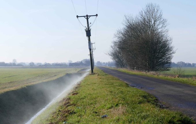
Meanwhile East Fen between Halton and the silt lands remained stubbornly resistant to being drained. There were attempts to drain it when Tennyson was a boy but it would regularly flood during the winter months so that the land could not be ploughed and was used primarily for summer grazing. The problem was only fully solved in the mid nineteenth century when more efficient steam powered drainage pumps where installed. This changed the land from only being good for summer grazing to being some of the most productive land in Britain. From one of the last lowland semi wildernesses in Britain with stretches of open water called the Deeps, which were magnets for bird life, the fen was transformed to a man made landscape partitioned by long straight lines of drainage ditches and roads with the ultimate expression of bringing this remote corner of Lindsey into the modern age – the East Lincolnshire Railway – bisecting the fen.
The dividend of this land improvement and the benefit of a railway station on the Spilsby branch line in the parish is evident in Halton’s parish church which stands on a final hill where the land falls away gently down to the flat fenlands. In 1847 the church was thoroughly restored after a violent storm had damaged the roof and continued to be improved and embellished throughout the remainder of the nineteenth century. These improvements included carved oak pews and a handsome oak screen, a new roof with the tower rebuilt and heightened, the bells rehung and a clock added. The chancel was repaired with the gable end being rebuilt, three windows opened and an elaborately carved pulpit and new altar added. Most importantly this all served to enhance the magnificent medieval core of the building – a graceful lofty perpendicular nave and clerestory dating from 1400.
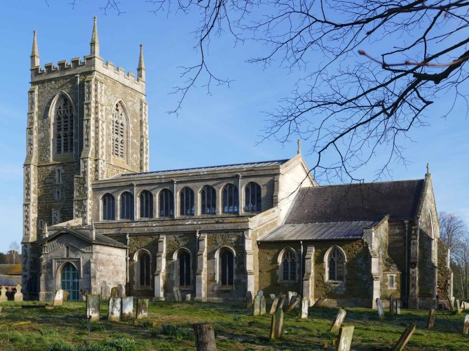
A screen underneath the east window of the north aisle lists all former rectors, clerks and churchwardens and was installed in 1911 with 1224 as the earliest date mentioned. Included in the list of rectors are two Rawnsleys. Thomas Hardwicke and later his son R. Drummond Rawnsley had a great influence on the parish through over half a century from 1825 to 1881 and were responsible for some of the improvements to the church like the new roof and tower. They also had a great influence on Tennyson who often stayed at the rectory in his younger years and continued to have close ties with the family throughout the rest of his life.
In his later years, long after leaving Lincolnshire, the then Lord Tennyson would rely on his old friend, who had since returned to Halton to take over as rector from his father, to check the accuracy of his Lincolnshire dialect poems. It was Drummond in fact who inspired Tennyson to write The Churchwarden and the Curate after having related the story to Alfred and includes the line “If tha cottons down to thy betters an’ keeaps thysen to thysen”. The old rectory where Tennyson stayed still stands and after the church is the most handsome building in the village. For a time the two buildings were connected by a wooden bridge over the hollow way, which passed between and beneath them on its way down to the river.

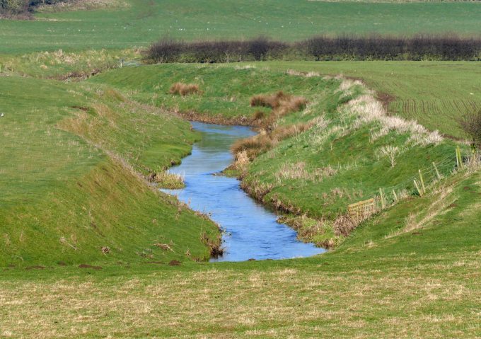
The hollow way was a third element to the parish fortunes in medieval times. Holegate is the road coming from Spilsby, which passing through the village has worn down a hollow through the sandstone before emerging on to the Lymn valley. This was not only a key crossing point of the river before it spills out onto the fen but also the head of navigation for traffic coming up the river. This was not the River Steeping, which is part of later drainage improvements cutting a straight line after leaving Halton between Great and Little Steeping all the way to Wainfleet All Saints. The original River Lymn in medieval times took a more easterly course to the sea passed Croft, which for a period was a port though little remains now of these more prosperous times except the unusually large church for such a small scattered settlement (See Welton Blog). This is also a clue to the origins of how Halton’s fine medieval church came to be built when there was a lucrative trade from boats discharging their cargoes at Holegate to pass through the parish up to Spilsby with its market and fair. The original course of the River Lymn can still be traced on OS maps but is little more than a roadside ditch in places. The sea is now much further away and even the railway has retreated away from the parish leaving Halton as just a very pleasant place to live if you work in either Spilsby or Skegness and a place from where you finally get a chance to walk along a length of the River Lymn for a while on the way to Ashby by Partney.
Flandrian – A Period of Rising Sea Levels.
6000 BC The Islands of Britain and Dogger co-exist for a brief time with Baltic like coastlines fringing an emerging sheltered southern North Sea.
5000 BC A Long Dogger Reef still absorbs the energy of storms entering the North Sea affording some protection to a fragile east coast but main valleys are submerged making the coast very indented. Creating a coast similar to that of present day Lancashire with broad estuaries between prominent headlands. At this time the extra area of land east of Lindsey would have been about the size of Norfolk but very low lying and broken up by wide estuaries and shallow lakes.
4000 BC The First storm surges begin to penetrate and start to the destroy dune coast and rip through peat that has built up to the rear.
3000 BC Storms erode the soft coastline back to its present day extent but inundations extend well inland and up the Witham valley creating a much larger Wash than now. The sea had inundated so much land Lindsey had become a virtual island during the highest tides which would surge up the Witham valley almost to Lincoln. This is the origin of Lindsey as a geographical region recognisable to us but with a south coast stretching from Ingoldmells to Dog Dyke!
2000 BC Further inundations by the sea continue due to gradually rising sea level. The first evidence of salt making.
1000 BC An increasingly wet climate increases peat build up in river valleys.
0 AD Salt making widespread in creeks and inlets. This only increases with the arrival of the Romans.
1000 AD The silt lands around the Wash are being widely settled and farmed. Sometime during the eleventh century Lindsey becomes part of Lincolnshire acknowledging the movement of people on to the new land around the Wash from both LIndsey and Kesteven. Uniting the area into one large county.

Nice photos
LikeLike