Candlesby, in a sheltered spot on Lowgate at the foot of the Wolds overlooking the flood plain of the Lymn, was an important village in a small parish at the time of the DB. As its name implies it was probably close to the meeting place of the Candleshoe Wapentake but it was also a soke with jurisdiction over other parishes out on the marsh. The hoe element suggests that the weapon bearers met on high ground or a mound above the village. This was likely to be close to the Bluestone Heath Road as the meetings for the Calcewath and Hill wapontakes were also by this ancient ridgeway. Its proximity to good roads and good land always made Candlesby a popular place to live.
The short journey from Monksthorpe to Candlesby reveals a sudden change in name endings from a cluster of thorpes to a cluster of bys; from Northorpe, Keythorpe and Monksthorpe to Scremby, Candlesby and Gunby. The bys are thought to be primary settlements and thorpes secondary settlements from the time of the Danelaw. The primary “by” settlements found on higher ground along Lowgate, the road to the coast. On the other side of Long Rigg there is Ulceby, Rigsby, Claxby and Willoughby on the higher ground and Farlesthorpe, Bonthorpe and Hasthorpe on low marshy ground.

It has been said that the Danes chose lighter inferior soils away from earlier Anglian settlements when they settled down to farm the land in the late ninth century, This is clearly not the case in this part of the South Riding where Danish names dominate and spread out away from both sides of the Bluestone Heath Road in the densest concentration of such settlements in the whole of the British Isles. However what the Danes were prepared to do was exploit inferior land. In the examples above it looks like a simple natural step to utilise uncultivated land close by but this was also done on a much grander scale as will be seen when we reach Calceby. There communities worked together to exploit marginal lands close to the sea far from where they lived on the edge of the Wolds. On reaching Calceby I will attempt to give a more detailed and hopefully clearer picture of the South Riding at the time of the DB.
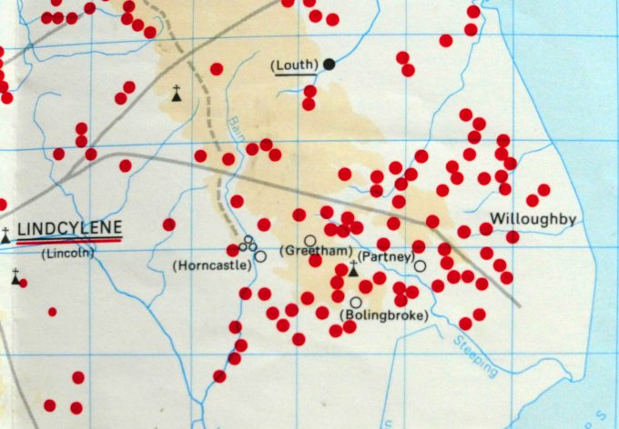
Unfortunately it is not always as straight forward as linking a higher ground settlement with a nearby one on lower ground. Candlesby, Rigsby, Claxby and Willoughby were all small sokes with lands spreading across Calcewath and Candleshoe wapentakes. Sokes were ancient estates whose origins could predate the influx of the Danes. Only the lord of the manor of Willoughby has his lands in close proximity to him. The lands tied to Claxby’s lord were all well to the north of the soke centre and Rigsby soke has land stretching all the way to the coast. All these lands are on the marsh even though the lord was based on higher ground. We will see that this is a common theme in the South Riding.

What is clear is that in Lindsey these sokes often had an exceptional number of sokemen compared to the rest of England. Sokemen were not tied to the land like the other classifications of peasants. Sometimes sokeman is translated to freeman but in a feudal society this was only a relative term. Pauline Stafford – The East Midlands in the Early Middle Ages – Freedom is not an absolute. It is freedom from certain demands, exactions from onerous labour services. It is also freedom to do things, to sell land, to go with one’s service to a new lord, to attend the local court of the wapentake and hear one’s case heard there… They proved these freedoms in court in the age old way, with the brandishing of weapons that symbolised them.
This hints at a more dynamic society than the rest of the country at this time and the DB captures a moment in time when in Lindsey there was much land improvement and reclamation taking place along the coast and its marshy hinterland. This was mainly systematic under the control of the lord but in some cases like at Addlethorpe and Wainfleet it appears more opportunistic especially when, like with Saltfleet and Wainfleet, they developed into ports capitalising in the growth of the post conquest trade with Flanders. The most extreme case was Skirbeck, a small outlier of the Bolingbroke soke, which in a remarkable short space of time became the major port of Boston. At its peak around 1300 it was second only to London in trade. With such new opportunities and growth taking place it was practical to have your workforce not all tied to a single parish hence the preponderance of sokemen.
Candlesby’s soke meanwhile has land scattered further afield than all the others and in all directions except west. The entry for Candlesby in the DB includes two churches but this does not necessarily mean in the same parish, which in Candlesby’s case was particularly small. The second church could potentially be miles away but sponsored by Candlesby’s lord who also need not be based in the village but only have jurisdiction over it and would normally have a man resident there keeping an eye on things for him. One of the biggest land owning lords in the South Riding before the conquest was King Harold. Referred to in the DB only as Earl Harold he had estates across Lindsey but his largest estate by far was in the South Riding covering large parts of Hill and Calcewath wapentakes. If this was not confusing enough much of the land around Candlesby belonged to the Bardney soke miles away to the west of the Wolds. But this anomaly will be explained on the return journey (See Partney & Spilsby Blog).
What is clear though is despite Saxon successes on land regaining parts of the Danelaw in the tenth century the occupation and settlement of islands and peninsulas by Norwegians in the west and Danes in the east around the coasts of Britain shows that the Scandinavians remained in control of the seas. They had settled at strategic places along both coasts such as the Wirral, Flegg Island in Norfolk and at the mouths of the Eden and Tees rivers while the Humber estuary remained a Viking highway for 250 years. The Isle of Man remained part of the Norwegian crown until the second half of the 13th century with its own parliament called the Tynwald which still functions today.
Even this island which is similar in size and shape to the Lincolnshire Wolds was not as heavily settled by Scandinavians as Lindsey never mind the densely populated South Riding. Unfortunately instead of being a semi autonomous region like the Isle of Man, able to retain its ancient land divisions fixed during the Viking era, in 1974 Lindsey was ripped apart by boundary charges that cut a jagged line across this distinct historical and geographical entity as if cut with a pair of very blunt scissors. This was at a time when British civil servants denied the ability to draw arbitrary lines across other regions of the world with devastating effect turned on their own country. Government finds it inconvenient to recognise ancient boundaries even those of old kingdoms but also the differences of the regions. The southern Danelaw, which was granted legal autonomy in 962 has never been obsessed by France or tied down in conflict with Scotland but quietly busied itself in building trading relations with first Scandinavia, then the Hanseatic league and the Low Countries.
A thousand or more years ago there was an inviting similarity for the Danes when settling in eastern England that reminded them of home. Then Denmark was made up of two peninsulas, Jutland and Scania, with a cluster of small islands in between. This also described eastern England at the time although instead of straits of open water the land was separated by bays, rivers and marsh or fen. In England’s case the two peninsulas were Holderness and Norfolk and in between stretched vast watery areas of marsh and fen separated by rivers flowing sluggishly into the estuaries of the Humber and Wash. In between emerged the higher ground of Axholme, Lindsey and the Isle of Ely plus other smaller islands.
For comparison Lindsey and the Danish island of Fyn or Funen were similar in size and today are both connected by bridges to the mainland. A thousand years ago there was only one way into Lindsey that avoided a ferry crossing and that was through Lincoln. The island of Fyn meanwhile was connected to the mainland just under a hundred years ago by a bridge, which crossed the narrow stretch of water called the Little Belt to Jutland. Today the island is also connected by impressive bridges to the large island of Zealand and other smaller islands and now probably feels less isolated than Lindsey’s east coast does to the rest of England.
If you think that crossing fen not as difficult as crossing open water just consider how much trouble William the Conqueror had ousting Hereward the Wake and his fellow rebels from their refuge on the Isle of Ely. It should have been a strategy that Boudicca could have adopted instead of taking on crack Roman troops on open ground. When William finally built a causeway across to the island he found that Hereward had vanished into the maze of waterways hidden among a forest of tall reeds.
Tennyson must have noticed the difference in place names when he moved to the home counties and we know he was well aware of dialect differences but he did not take this any further. His greatest work in later life was Idylls of the King, the legends of King Arthur, which he spent many years writing and later perfecting. It is a curious hybrid of Dark Age Welsh myths and high medieval romantic ideals. At the same time he penned a number of Lincolnshire dialect poems like the Northern Farmer but showed no interest in Lincolnshire history or legends such as Hereward’s defiant stand against William the Conqueror, the history of the Dark Age Kingdom of Lindsey or the local legend of Havelock. He was a great linguist, which is an essential skill in reading original manuscripts, but seems not to have been interested in history or even the many social issues of his time. His main inspiration was relationships, especially his own, and particularly his closest with Arthur Hallam and his loss after an untimely death in 1833 at just 22 years old. The devastation this brought to Tennyson was first expressed in Morte D’Arthur, which much later, in a revised version, became the ending of the Idylls of the King.
