Now in Hill wapentake we have left behind the busy main roads of the twenty first century and by the time we get to the quiet and secluded twin parishes of Tennyson’s Somersby and Bag Enderby it will feel like the twentieth century has been left behind as well as little has changed there since his time. This is also true of the South Ormsby estate. The estate of 3000 acres is largely contained within a wide valley which fills the gap between the Ulceby Chalk Island to the south and main chalk escarpment extending away to the north. We have been passing through this large estate since leaving the A16 and are now arriving at its centre. This estate has been intact for 400 years and little has changed since the eighteenth century so even since Tennyson’s youth little will have changed except for more and bigger trees now surrounding the hall.

The first buildings you pass after entering the parish of South Ormsby belong to Keal Farm. It is quite likely that the farm name was inspired by the series of small hills on the opposite side of the road. These low ridges were formed during the height of the last ice age by copious amounts of melt water flooding between them for a brief period. There are four melt water channels, starting from the west with each slightly lower than the next, which form three long narrow hills between them. When looked at from the farm, they have the appearance of three up turned long ships with their keels pointing toward the sky. By the road though this evocative image have been somewhat muted by modern ploughing.
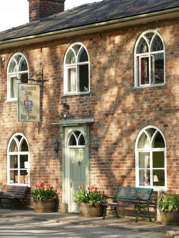
The village of Ormsby starts at the crossroads where there is a cluster of ordinary looking dwellings. From here the village is strung out along the road that heads south with mature parkland along the whole length of the village on the road’s west side. An old iron gate, just a hundred metres south of the crossroads, allows you to enter the parkland along a footpath that eventually takes you to Tetford and is opposite the small Massingberd Arms pub which offers the chance of refreshment either before or after your walk across the wooded parkland.
UK Biodiversity Action Plan Priority Habitat Description.
Wood-pasture and parkland are mosaic habitats valued for their trees, especially veteran and ancient trees and the plants and animals that they support. Grazing animals are fundamental to the existence of this habitat. Specialised and varied habitats within wood pasture and parkland provide a home for a wide range of species, many of which occur only in these habitats. The extent and richness of the UK wood-pasture habitats are outstanding in the northern European context.
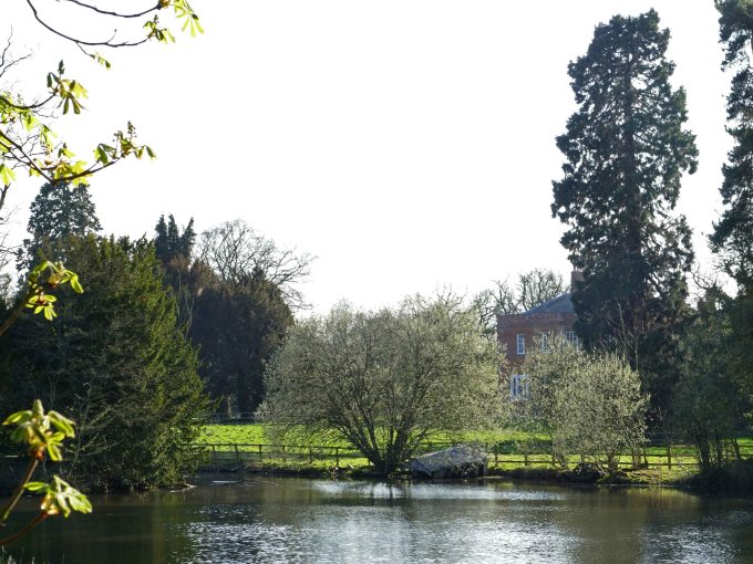
After this promising start the village only becomes more inviting. Set in a sheltered valley you now cross a chalk stream, which passes under the road and then flows beside it for a little while. On the other side of the road the stream, whose source is just two kilometres away in Oester Dale on the western edge of the estate, plays an attractive melody as it flows over a small cascade. This is part of a dam that forms a lake which unusually does not follow the course of the stream as it passes through the parkland but is perpendicular to it stretching three hundred metres south narrowing as it does so. This would suggest that at its southern limit there was a spring now hidden beneath the waters of the lake. The best prospect to admire the lake from is from close by the cascade.
Next there is a break in the village for half a kilometre with only a track to Manor Farm beside what was once the old post office. The new owners of the South Ormsby estate plan to extend and refurbish the farm’s cluster of buildings to create a heritage centre. This will eventually include a cafe, exhibition and gallery areas, as well as retail, craft and business units. It is also proposed to increase the number of houses at the north end of the village.
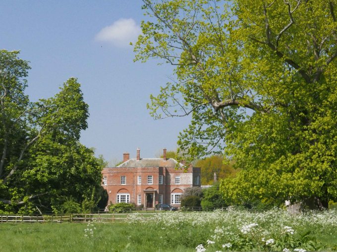
The lane meanwhile continues to meander its leafy way to the southern end of the village. This soon passes the entrance to Ormsby Hall, a grand eighteenth century building originally built by James Paine, set handsomely beyond the lake amongst tall trees. One cluster of these fine specimens is a copse of beeches soaring a hundred feet above the lane and includes an exceptional elm. They overlook the old school house and its one time playground. This is the first of a cluster of buildings at the foot of the hill on which the parish church of St. Leonard stands.
The hill topped by the church with its tall tower and mature trees is partly why the beeches sheltered below beside the lane were able to grow so tall. Although they is exceptional for a Wold village it is not unusual to find tall trees in the Wolds. These however are most often hidden away in deep valleys further north. This is because the glacial melt water channels there had longer to cut deep narrow valleys into the chalk before the ice retreated after the last glacial maximum. Some, such as Welton Dale, Swallow Vale and the Valley near Wold Newton, hide trees well in excess of a hundred feet.
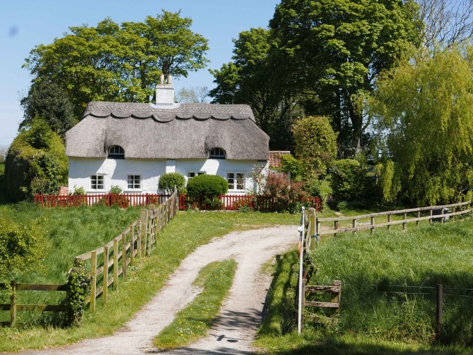
The final building at the southern end of the village is a pretty thatch cottage set back from the road where it forks. One lane continues south to Brinkhill while the other rises sharply uphill to become part of the Ormsby Ring. Stepping back into the village a little way there is a choice of footpaths that enable you to explore the extensive estate further. On one side of the road is a footpath leading east, which splits into two behind the thatched cottage. One fork heads across to Calceby and the other east to Driby but this latter one splits again with options to turn north or south before entering the large wood of Furze Closes.

On the opposite side of the road is a path that leads up to St Leonard’s church with its door (usually open) and tower clock on the north side facing the hall. At the far end of the churchyard the path continues through a gate into the estate’s extensive parkland to pick up the Ormsby Ring at the park’s west end after about half a mile away. By returning along the Ormsby Ring road, which curves around the parkland you get the reward of wide views over broad valleys to the encircling hills. Much of what is visible belongs to the estate as far east as the A16 where lorries can be seen on the horizon climbing up to Driby Top three kilometres away. The estate remained in the hands of the Massingberd family for nearly four hundred years with only gradual changes occurring over that time. The estate has recently changes hands however and now is owned by the Thornes which is why the proposed changes to the village, Manor Farm and the wider estate are planned to take place.