Just a kilometre from Calceby is the boundary between Calcewath and Hill wapentakes. Not that you would know as you passed through. This location is deceptive though in its ordinariness. From the top of Keal Hill just about two hundred metres to the north there is an impressive panoramic view especially for such an unremarkable eminence.
The line of the ancient Lindsey meridian passes just west of the hill and looking back to the southeast there is a view back to the high ancient Hub and in the opposite direction a view up Ketsby Dale to Deepdale. Incidentally if you extrapolate this line in both directions it not only splits the Wolds in two but also Lindsey. The southern end reaches the sea just north of Gibraltar Point and the northern end passes close to Alkborough overlooking the point where the Trent flows into the Humber. The line intriguingly then can be followed across the Vale of York to the Thornborough Henges complex near Ripon and predates the present Prime Meridian which passes through the Wolds by 5,000 years.
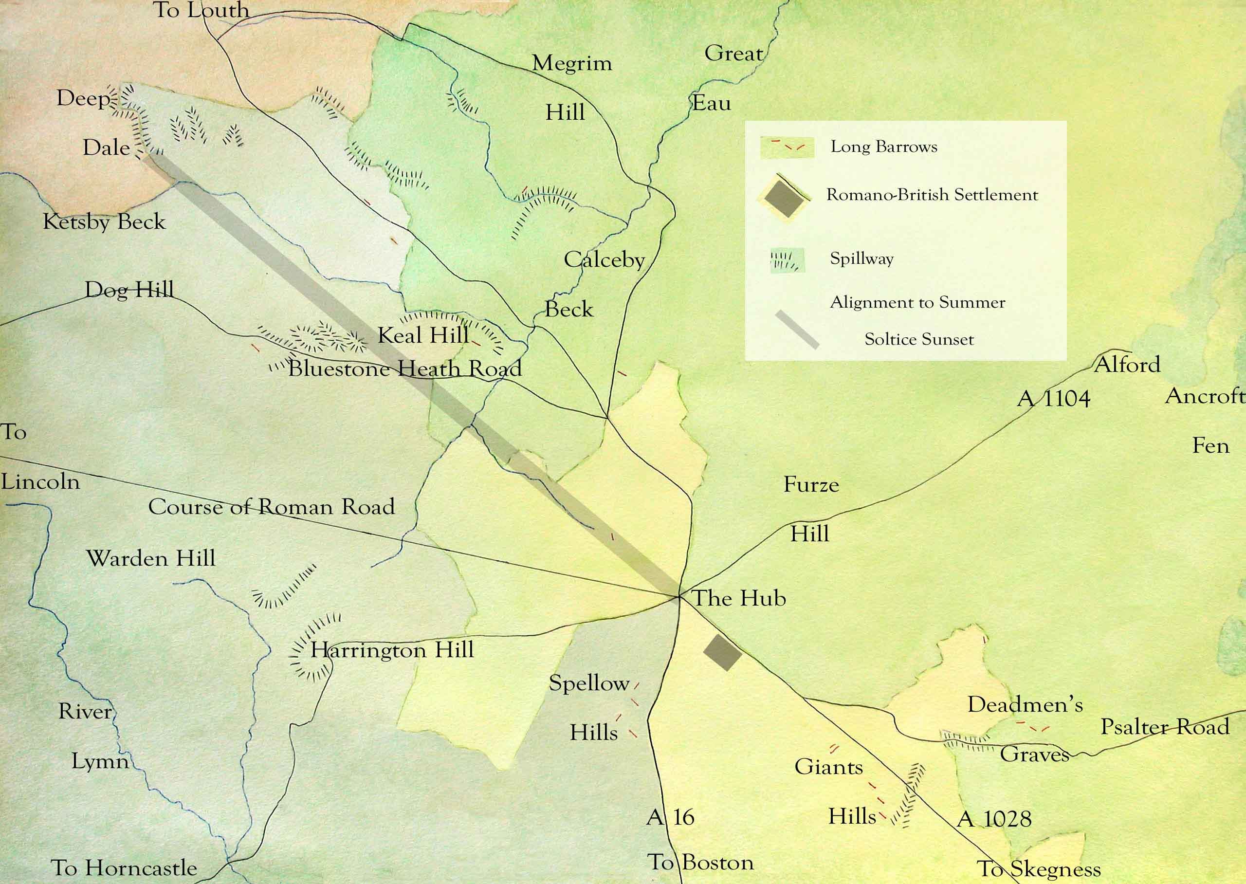
As mentioned previously this also coincides with the line of the terminal moraine from the last glacial maximum, which is why the hill appears from the road to have such a gentle gradient although it does fall away more steeply on its northern side. There are thick morainic deposits on three sides of the hill softening if profile yet to the west the landscape displays a series of erosive features (spillways) made by melt water escaping from the glacier as seen in the image above.

The glacier completely disrupted and rerouted the drainage pattern of the whole valley. This will be examined in more detail later (See Upper Lymndale Blog.) but in the immediate area both the Ketsby beck and the beck coming from South Ormsby have been deflected south by the glacier’s terminal moraine. The former beck cutting into Keal Hill and the latter being pushed away from it. Skirbeck, which flows through Swaby, and Calceby Beck were deflected east which suggests that behind the moraine for a time was a large section of stagnant ice left behind as the glacier retreated. This then stopped for a time along the line of the Hogsthorpe moraine just to the north while the climate cooled again so that the stagnant ice filling the valley, between where Swaby and South Thoresby are now, to melt only slowly allowing the formation of the steep sided Swaby Vale.

To the west of Keal Hill are a set of shallow melt water channels or spillways cutting across the lowest part of the ridge formed in only a short period of time by large amounts of melt water flowing south from higher in the Wolds having been unable to flow east with the glacier, known as the North Sea Lobe (NSL), blocking all the main valleys out of the Wolds. As the water flowed through these valleys for only a few years and then more recently have been regularly ploughed their profiles are not as sharp as Swaby Vale or Deepdale but they are close to the road and illustrate clearly how dynamic and different the landscape was 20,000 years ago.
Features associated with Lindsey’s Ancient Meridian.
- The top of Deepdale is critically at the same height as The Hub. At 8 km distant it appears a similar size to the sun making for accurate observations.
- The meridian crosses the broad valley of Calceby Beck, which trends NE-SW. The winter solstice sunset is observable through Brinkhill gap from the evocative location of the ruined church at Calceby.
- The two tributary valleys of Driby Carrs and opposite Ketsby Beck afford a clear view from the Hub NW to Deepdale even across a wooded landscape.
- Driby Carrs is also the line of the largest fault in the Wolds AONB. This marks the abrupt end of the vivid line of red chalk to the west and the beginning of long barrows restricted to the white chalk.
- Blocking glacial deposits prevents cold air drainage causing a river of mist to easily develop around Keal Hill.
- West of Keal Hill are a series of low hills beside the Bluestone Heath Road have the appearance of a cluster of large natural long barrows. These were produced by a series of glacial spillways and are crossed by the line of the ancient meridian.
- Notably there are four groups of long barrows besides ancient tracks converging on the Hub. Spellow Hills beside the A 16 north of Dexthorpe, Giants Hills close to the Bluestone Heath road south of Ulceby, Deadmen’s Graves overlooking Psalter Road Claxby and Beacon Plantation long barrow(s) on the edge of Walmsgate parish beside the A 16.As I mentioned earlier halfway between Calceby and South Ormsby the road crosses into Hill Wapentake. You could also say it passes into Tennyson Country because the bard grew up in the middle of the wapentake. Unlike all other wapentakes in the South Riding it does not stretch beyond the Wolds which gives it a uniquely closed in feeling. The absence of main roads means it has to be discovered by travelling winding lanes, which reveal that much of the area has changed little since Tennyson spent his youth here. The twin villages of his father’s diocese, Somersby and Bag Enderby, remain especially unspoilt but the large South Ormsby estate gives a foretaste of how slowly things change in this part of the world.
Hill Wapentake, is a thousand years old area of jurisdiction formed during the time on the Danelaw, enduring in a diminished form into the second half of the twentieth century and is also referred to by the Anglo-Saxon equivalent of Hill Hundred. It stretches 15 kilometres north to south from Walmsgate to Claxby Pluckacre and thirteen kilometres east to west from Langton to Fulletby or more precisely from the A16 to the River Waring.
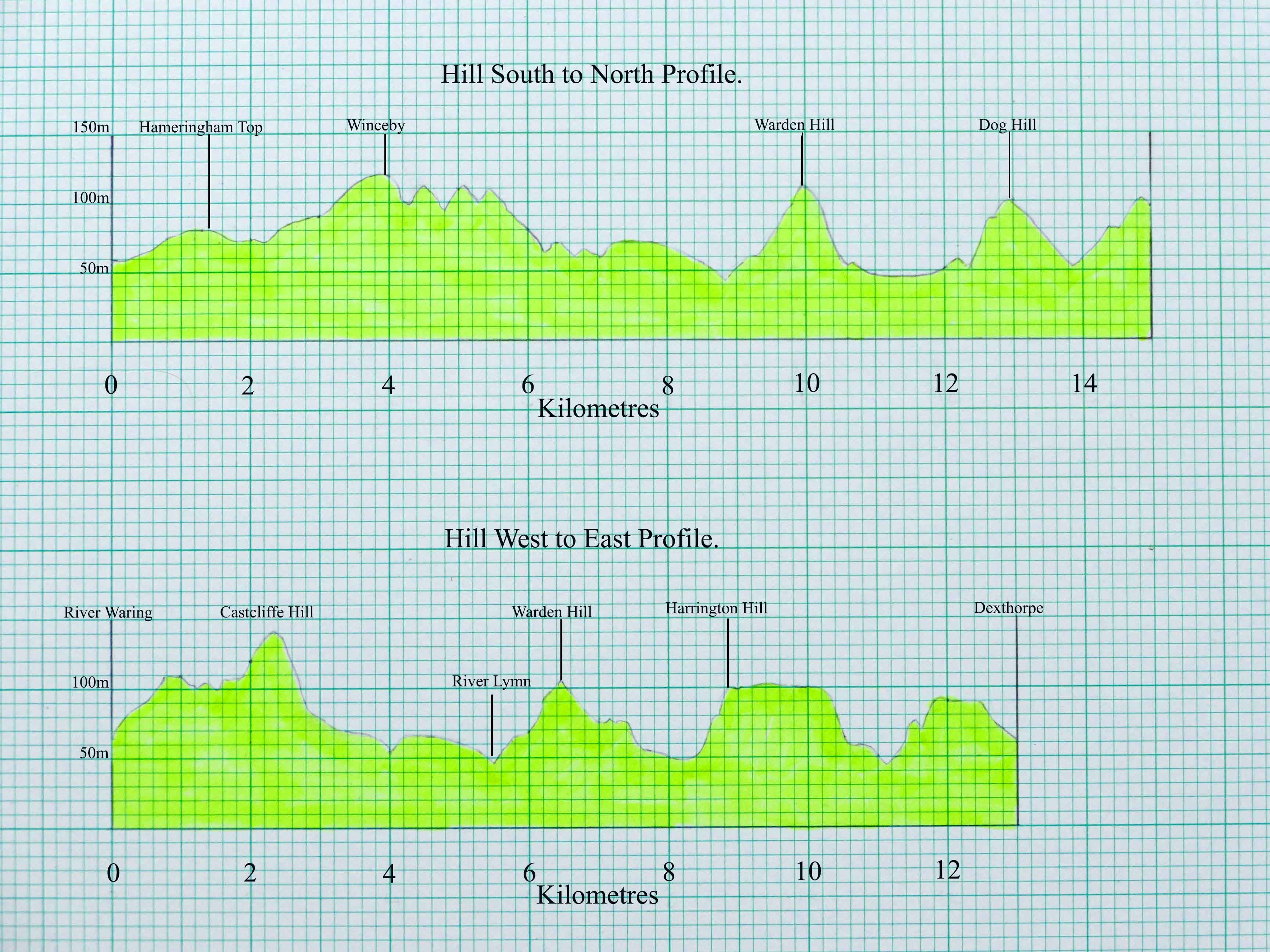
From the profiles of the area, both crossing the wapentake via Warden Hill with Tennyson’s Somersby tucked underneath, it shows how this little village is close to its centre. For a young Alfred this was his world and from the top of Warden Hill he would have been able to see most of it. To the north is the broad flat Upper Lymndale and to the south the more deeply eroded Lower Lymndale and beyond both bold ridges that enclosed his world. These are of chalk to the north and east and mainly sandstone to the south and west. The sandstone is particularly fretted and undulating but even the chalk escarpment is broken and uneven so that Hill Hundred is well named and gives the impression that it is made up of a hundred hills. Depending on what designates a hill this is probably not quite accurate but if you add the small neighbouring wapentake of Gartree to the north stretching up the Bain valley, another little world comprising a deep valley enclosed by a huddle of hills, the hill count should be sufficient.

Without historical maps these areas are difficult to define but to give a rough idea of this enchantingly unspoilt area of Lindsey’s old South Riding it is probably easier to use modern roads to define it. The three market towns of Horncastle, Louth and Spilsby are connected by main roads that cross the Wolds. The A158 heads east to the coast bypassing Spilsby to the north. Ninety percent of Hill Wapentake lies to the north of the road before it reaches the little hill town. The A16 heads north from Spilsby to Louth via Ulceby Cross and loosely forms the wapentake’s eastern boundary until descending Walmsgate Rigg into Burwell. The A157 connects Horncastle to Louth the largest of the three towns. Leaving Horncastle the road follows a low ridge north. To the east across the valley of the little River Waring is a more prominent ridge. Its west facing slope is the western boundary of Hill Wapentake and after passing through West Ashby the A157 enters Gartree. It splits the wapentake, the bulk of which lies to the north of the road. The road leaves Gartree at the crossroads with the Bluestone Heath Road near Cadwell Park. The ridgeway mean time forms the eastern boundary of the wapentake as far north as Gayton le Wold already referred to as the tiny hamlet whose soke once spread right to the coast and was later reformed as Louthesk Wapentake. 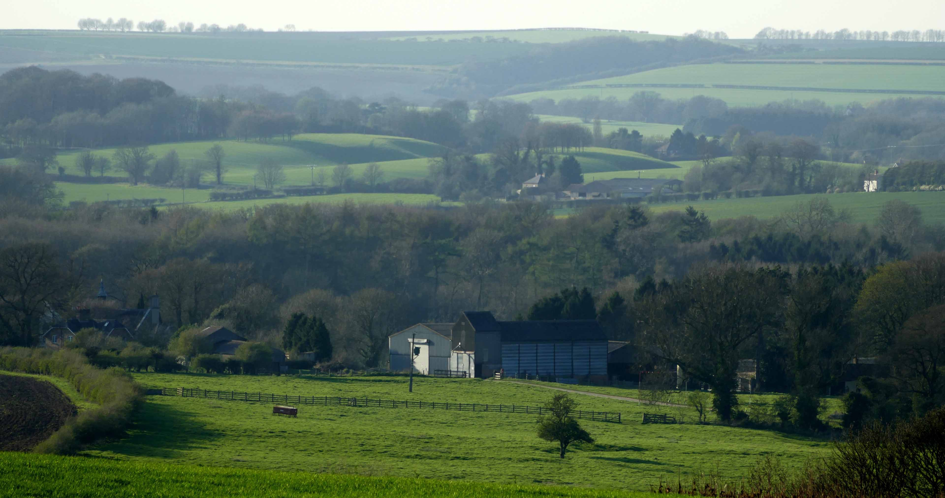
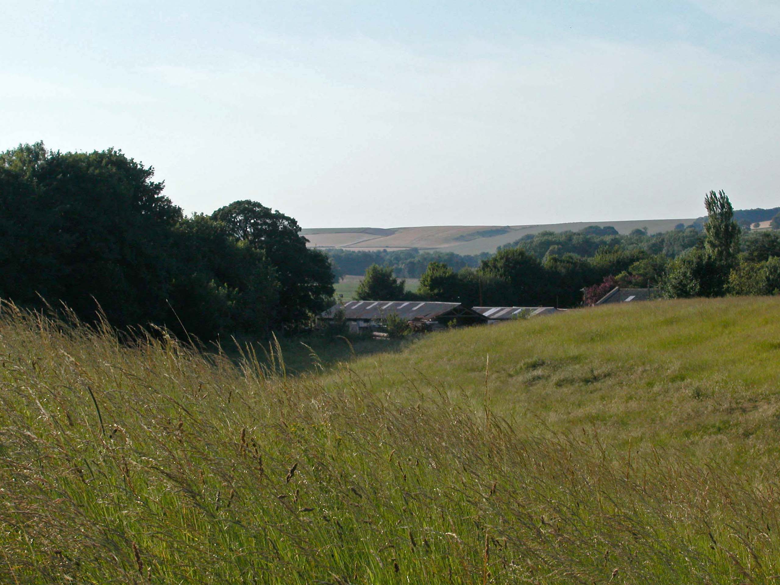
Looking across the South Ormsby estate and several peri-glacial features.