The Heritage Gateway website describes Calceby in detail –
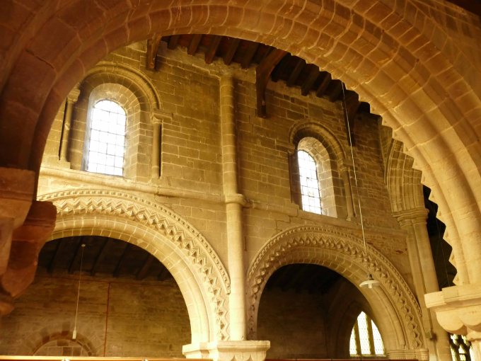
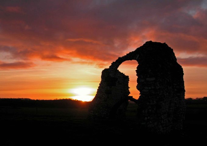
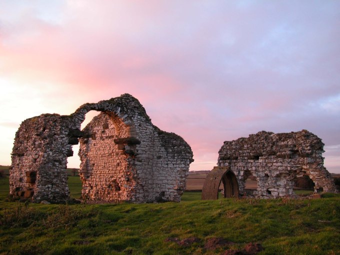
Calceby is mentioned separately in Domesday and assessed in medieval tax records. In 1377 60 people paid poll tax and by 1563 18 families remained. A priest was last instituted in St Andrew’s church in 1540-70. The Norman church now survives as a ruin to a maximum height of 5.5m. Surrounding the church are areas of desertion and remains of a moated site. House platforms and streets can be seen in aerial photographs. Three ruined, thatched cottages of 14th and 15th century date still stood in 1964 and appear to have been associated with the original village.
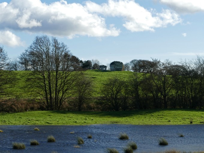
Leaving the A16 just over a kilometre north of Ulceby Cross the Bluestone Heath Road veers off left to head down to Calceby, leaving one ridge before it can climb another. Today Calceby is just a quiet hamlet with a few scattered barns and houses either side of a small beck. There is very little left of the church, which has stood abandoned for centuries on a hill overlooking Calceby Beck. For over 300 years it has been part of the large Massingberd Mundy estate, which is centred in the next parish of South Ormsby and also stretches into the forgotten parish of Driby. Yet at the time of the DB these three parishes were all in separate wapentakes with different lords.

In the DB Calceby is grouped with nearby Haugh but also Mablethorpe, Theddlethorpe and Wainfleet and also separately with Withern and Aby. Collectively they have a total of 83 sokemen, 33 villans and 35 bordars and 1000 acres of meadow and twenty saltpans. Before the Norman conquest Calceby’s lord of the manor was Earl Harold who in 1066 was briefly King Harold. Busy with affairs of state he was clearly an absentee landlord whose estates were administered from Greetham 10 kilometres to the southwest. Greetham today is not much busier than Calceby but it still has a church and a small community. Back in Harold’s time though it was the centre of a large soke that had jurisdiction over a vast area, which stretched to the sea. This is the direction in which Calceby’s interests also lay at this time. Greetham soke covered two wapentakes Hill and Calcewath. The latter means the ford at Calceby, which is where wapentake meetings were held despite being at the western extreme of its jurisdiction.
Because the Greetham soke was so large and complex by examining the smaller Gayton soke just to the north it shows a much clearer picture of what was happening in the South Riding at the end of the eleventh century. Gayton like Greetham is found deep in the Wolds but most of the soke stretched out across the marsh east of Louth. Starting at Alvingham it widened towards the coast around Saltfleet. The Gayton soke’s cluster of Saltfleets were just across the Great Eau from the Greetham soke’s two Theddlethorpes. Gayton soke like the Calceby group had a port, saltpans and a large acreage of meadows. The parishes of North and South Somercotes, just to the north of Saltfleet, suggest that living on the coast was of a seasonal nature. What Gayton soke shows clearly, thanks to the DB, is the soke’s value doubles between the beginning and end of William the Conquer’s reign as a consequence of securing new land and settlements from the sea and marsh.
This was not the end of the story, which can be picked up in White’s 1892 edition. It gives a fascinating window into a world that had only changed slowly of the next 800 years to reveal that the lord of the manor at Gayton continued to have land in the parish. Yet he was not the majority landholder as enclosures had enlarged the parish, incorporating both salt marsh and sand hills. The directory in unusual detail continues “North Somercotes in 1891 had 8,622 acres of land, of which 700 hundred acres were not enclosed till 1841: but the Marsh (2200 acres) of the two Somercotes was enclosed under an Act passed in 1630. There is still a rabbit warren of 150 acres. The parish is in Simon Thomas Scrope’s Esq., manor of Gayton but the greater part of the soil belongs to numerous other proprietors. Part of the parish has fertile loamy soil and the rest is sandy. At the north end of the parish was formerly a rich salt marsh of 300 acres, called the Fitties. On the southern coast of the broad mouth of the Humber great quantities of fish were caught near the headland of Donna Nook.” This description gives a clear picture of the opportunities to be had in areas of marginal land and the enterprise needed to exploit it.
Also in Louthesk is the strange anomaly of an outlier of the Greetham soke at Legbourne in the middle of the Wapentake. What stands out is the area incorporates both Legbourne and Little Cawthorpe although the latter is not mentioned in the DB. This grouping two villages together is quite common especially in Lower Lymndale as will be seen later (See Mystery of the Missing Parishes Blog.) and suggests that just because a place is not mentioned in the DB does not mean that the settlement does not exist but has a close relationship with its neighbour.
In the case of Calceby its entry is grouped with several other parishes which stretch along the south bank of the Great Eau far out into the marsh. A similar thing happens on the north bank of the river with Swaby, South Thoresby (sic), Belleau, Claythorpe and Tothill. As they are so similar to the Claxby, Rigsby and Willoughby sokes just to the south it stands to reason that Calceby and Swaby were also once independent soke centres with lands stretching out over the marsh before they were assumed into an expanding Greetham soke. The locations of both Calceby and Swaby compare favourably with the clear majority of other soke centres in the Wolds as being found in wide valleys served by ample water from springs and clear streams.
With the Calcewath wapontake we know exactly where the wapontake meetings took place, which was by the ford on the Bluestone Heath Road. With other meeting places like Candleshoe for example we know roughly where they met but with others like Hill we can only guess. As Calcewath and Candleshoe were both on or close to the Bluestone Heath Road it is also likely the Hill wapentake met on it as well possibly at Dog Hill for example. This is not far from Calceby, its sister site, as both wapentakes probably had their meetings reported to the soke centre at Greetham.
Thanks to the information that the Domesday Book gives it is also possible to speculate on what they talked about at the Calcewath meetings. With the on going development along the coast and its marshy hinterland there would have been a deal of talk about rights and obligations on draining or enclosing land as well as the opportunities it could bring. But such work would need resources and manpower to accomplish such a task. It would be an opportunity for ambitious strong young men to prove themselves and ultimately benefit from their endeavour by being awarded a piece of land to manage.
Although this enterprise would have been welcomed by the Norman’s for its greater tax revenue they would have been less comfortable with its informal nature. Earl Hugh, Harold’s successor, had his man in most every parish of which he was lord and those twin symbols of feudalism, castles and monasteries, spread like a rash across Lindsey. There were two large motte and bailey fortifications built in the marsh. One was at Tothill where the Great Eau became navigable and another at Castle Carlton by the Carlton Beck or Long Eau. During the twelfth century the Normans took measures to institutionalise land management by establishing a ring of religious houses around the Wolds. With a Cistercian monastery east of Louth and the abbeys of Bardney and Revesby owning large tracts of land to the south of the Wolds and Thornton abbey dominating the north with lesser religious houses in between. (See Greetham Blog.)
It does make one wonder if Harold had defeated William at the battle of Hastings whether his laisse faire approach to his estates where individuals or small communities were allowed to use their initiative, as was the case in Lindsey, might have benefitted the rest of England instead of coming under the more centralised systems introduced by the Normans. For a brief time in the Danelaw there must have been a relaxing of the feudal system when the great wealth hoarded by the Anglo Saxon monasteries in this region was liberated and put back into the economy. Danes, and Harold was half Danish, were not as obsessed with bureaucracy as the Normans allowing greater freedom.
The establishment of continental monasteries from the twelfth century onwards curtailed this enterprise making the thriving sokes become backwaters but the impetus could not be stopped entirely because further south in the silt lands around the Fens was an even larger area for the establishment of free parishes with the continuing reclamation of large tracts of land from both sea and fen. Creating some of the largest and richest parishes in England boasting some of the country’s most magnificent parish churches. Even at the time of the DB Bicker, which is deep in the Fens but far from the present day coastline, had 59 households. This was considered very large by general DB standards but was just average size for the Fens at the time. The parish also had twenty saltpans showing it still had access to tidal water and a church, which was replaced soon after the DB. This part Norman, part Early English church can still be admired today as can the large mounds left from medieval salt making in an otherwise flat fen.