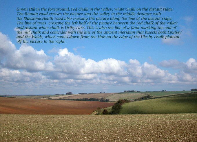
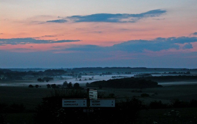
The exit from the roundabout opposite the entrance to Gunby Hall is the A1028, which climbs steadily onto Long Rigg. This is confirmed when the road takes a sharp right after passing the entrance to a chalk quarry and then at a sharp left turn it joins up with the course of the old Roman road, which itself follows the route of the prehistoric Bluestone Heath Ridgeway. From Welton High Wood this ridge stretches four and a half kilometres northwest until it merges with the main plateau. This is an island of chalk which is completely detached from the main body of chalk by a deep wide valley two and half kilometres further north. It will hence forth be referred to as Ulceby Chalk Plateau after the only village found on the plateau.
The Bluestone Heath Road, whose name is a reference to the local name for a glacial erratic, follows Long Rigg northwest until reaching 100 metres asl. Beyond the Ulceby Chalk Plateau the ancient ridge way splits from the course of the Roman road and after crossing Calceby Beck climbs up and follows the main chalk ridge into the centre of the Wolds as far as Ludford. I think however that it was this straight southern section crossing the plateau that gave it its unusual name as it is likely that bluestones were a large component of the Roman road. Whether this was from when the Romans originally upgraded the route or more probably during the many centuries of repairs it under went bluestones would have been the material most readily at hand.
These hard wearing glacial erratics often of a handy size and shape are abundant along the Wolds eastern edge where they were left by glaciers after they retreated. For what must be thousands of years farmers would have had to clear them from fields when ploughing. In north Lindsey several eleventh century church towers are mostly or partly built from these stones with Scartho church having the best example. Using them also to fill potholes in the Roman road over many centuries would have eventually given this ancient ridge way it distinctive name.
Glaciation is also responsible for another feature of the road. Halfway along Long Rigg it is crossed by a small glacial melt water channel just after passing the second turn off for Skendleby. The otherwise long straight road dips suddenly before quickly resuming its steady climb. This depression can also be seen in the fields either side of the road but a combination of erosion and regular ploughing have softened its profile.
It was formed during the last glacial maximum. The glacier having pushed south from Scotland roughly along a course where the east coast is today. When the glacier pushed up against the edge of the Wolds, which previous to this had been a line of sea cliffs, it dammed the valley to the east of the A1028 and produced a small lake. This eventually overflowed at a narrow point in the ridge where the dip in the road now remains. Its waters then flowed south to join the River Lymn. The ice must have been at least eighty metres thick, equal to the height of the ridge, but probably twice this at its maximum. However it must have only been a temporary situation for the melt water did not have time to erode a deep channel like some found further north. This suggests that the glacier soon retreated from its terminal moraine, which had reached as far south as the present day North Norfolk coast and west across the Fens to just short of the line of the Greenwich Meridian. When sea levels returned close to their present day levels this long terminal moraine allowed for a causeway to run roughly between Boston and Bolingbroke and is now the route of the A16 where it crosses the northern Fens. The ice retreated to just north of where Alford now stands. Here it paused for a while to create a set of similar features called the Hogsthorpe moraine, a series of low hills across the otherwise flat coastal marsh, and more melt water channels crossing the Wolds to the northwest.
At the Gate Inn, just a kilometre further, the modern A1028 kinks away from the straight line of the Bluestone Heath Road/Roman road and heads towards Ulceby Cross. This is a turnpike road built in the eighteenth century and continues north beyond the roundabout as the A16. The old Roman road continued northwest, only a straight hedge now marks its route, to the edge of the Ulceby Chalk Island. At this unlikely spot was first an Iron Age settlement which then became a Roman centre. This now quiet spot must have had some significance for the Romans to build their road here direct from Lincoln in such an uncompromisingly straight line over hill and dale to reach this point. The Roman road to continue west to Lincoln dropped steeply down into a broad boggy valley bottom sixty metres below, though no evidence of its route remains until reaching Brinkhill. (See Upper Lymndale Blog.) The ridgeway meanwhile chose to cling to the edge of the plateau until finding a much more gradual descent into the valley and crossing it at a narrow point where there was a ford. Its route was probably the line marked by the Driby’s eastern parish boundary before turning left toward Calceby. Referred to in earlier times as Calcewath, which means the ford at Calceby.
To explain why this site on the edge of a high dry plateau was so strategic to the Romans but afterwards was quickly abandoned and forgotten needs a separate blog that goes much further back in time to explain the full significance of this site.
A Lost Prehistoric Ceremonial Landscape
It is indeed fortunate that this ancient landscape of the Ulceby Chalk Plateau was not singled out as an RAF base during the Second World War as happened with similar areas north of Louth. If it had become an airfield for bombers it would have suffered the same impact as Monksthorpe with the re-aligning or loss of prehistoric routes that cross it. It was only on Long Rigg near Skendleby that the RAF had a small radar station to monitor traffic in the air and along the coast from 1943 and in the 1980s it became an underground Cold War bunker for a while.
Thanks to aerial photography picking up outlines in fields (crop marks) we now know that there were once many long barrows on the Wolds nearly all on chalk the material they were largely made from. The number of long barrows on the Ulceby Chalk Plateau however was equal to the number found around Stone Henge with clusters to be found both east and west of the Bluestone Heath Road. As a result of ploughing and archaeology most are not visible from the ground but beside the A16 Spellow Hills still stands proud although somewhat irregular in shape. There are more long barrows placed on spurs jutting out from the main chalk ridge, which face the plateau across the valley of Calceby Beck. The best of these is described in detail when reaching Walmsgate. Meanwhile the HG website intriguingly refers to the Ulceby Chalk Plateau as follows –
The name ‘Spellow Hills’ is derived from the Old English ‘spel’ and ‘hlaw’ or ‘haugr’ which means ‘assembly mound’. The earliest recorded instance of the name is in the early twelfth century. The barrow lies just below the crest of a gentle rise 200m to the west of the A16 which marks the boundary with Dalby parish. The land rises gently to a point 1.2km north where the wapentakes of Hill, Calcewath and Candleshoe and the parishes of Langton, Driby, Ulceby and Dalby meet (TF 406 733). From here there is an extensive view in all directions. It seems highly likely that this was a meeting place for the people from all three wapentakes rather than that of a single unit.

Returning back to the A1028 another cluster of long barrows known as Giants Hills lies just beyond the sudden dip in the road and about 250 metres west of it. The name suggests a dramatic feature or even features and this would once have been the case possibly even just two hundred years ago, during Tennyson’s childhood, when the Ordnance Survey were first mapping the area in detail. Then there was probably more than one long barrow standing on the hillside with the largest sixty five metres in length. When it was built about 5000 years ago it would have been made of white chalk with an elaborate opening at one end. The barrow was destroyed by archaeological excavation nearly a hundred years ago with only an information board now marking the site.
These prominent features in the landscape were made by Neolithic farmers, who liked to mark their presence by building long barrows to contain the remains of their ancestors. The Giants Hills long barrow is aligned with the road or it could be that both are aligned to the midsummer solstice sunset? The ridgeway runs almost exactly southeast to northwest for thirteen kilometres, twice the length of Long Rigg, which significantly is also perfectly aligned with the setting sun of the summer solstice.

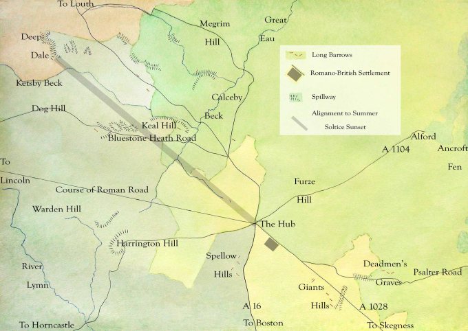
After climbing steadily along Long Rigg and across the plateau to eventually reach nearly a hundred metres asl at its northern end the land then drops down steeply into a tributary valley of Calceby beck. None of the many ancient ways that converge here choose to continue in this direction despite Driby being the nearest village to the ancient hub but fifty metres below it. From this vantage point however, 600 metres west of Ulceby Cross roundabout, on the summer solstice the sun sets right behind the deep ravine of Deepdale when viewed from this hub. Effectively continuing the ancient meridian line of the Bluestone Heath Road for another eight kilometres making this one of the cardinal points for ancient Britons. At the latitude of 55 degrees north, straight through the middle of Britain, the sun rises and sets at the points of the compass that we would recognise as NE, SE, SW, NW at the time of the solstices. There are many places in the north and west of Britain where ancient peoples have left monuments marking this phenomenon but this is rare for the southeast of Britain.

This extra aerial eight kilometres also happens to pass along the line of a large fault for these parts, the terminal moraine from the last glacial maximum and then along Ketsby Beck between the ridges of Walmsgate Rigg and Worlaby Rigg to the dramatic gash in the hillside which is Deepdale. This is a deep narrow glacial melt water channel cutting north south through Walmsgate Rigg. For the Wolds this is a major landmark being much deeper and with steeper sides than most other melt water channels in the area and marks the furthest point that the ice encroached onto the Wolds. (See Keal Hill & Ancient Meridian Blog.)
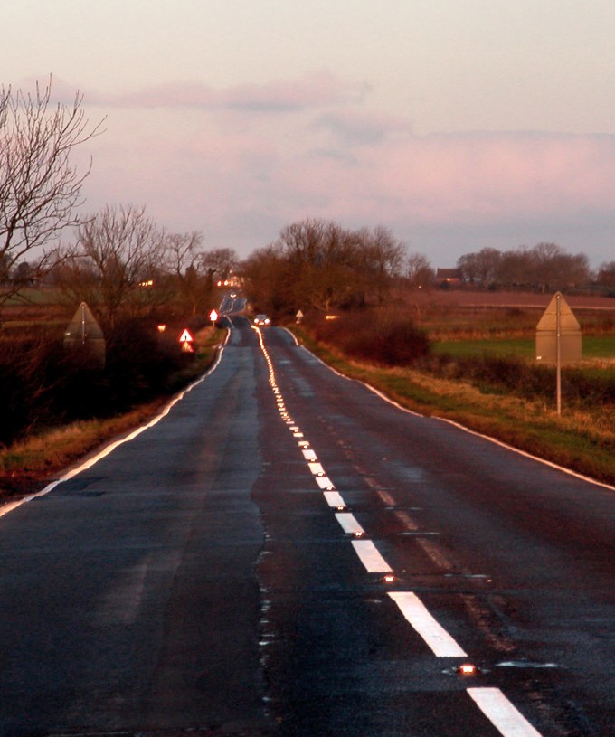
Interestingly this ancient meridian line fails to work in the opposite direction because to the southeast the land falls steadily away down to sea level eighty metres lower than from where you are observing unlike to the northwest, where the plateau is equal in height to Walmsgate Rigg. As the sun rises over the Wash at the mid winter solstice the effect created is still impressive though because with the shining waters of the Wash to your rear you will witness all the cats eyes down the middle of the Bluestone Heath Ridge road being lit up by the sun’s bright rays.
These phenomena alone would suggest that the ancient hub west of Ulceby Cross was a probable site for a prehistoric ceremonial centre and with the clustering of long barrows in the area increases the likelihood that this was a Neolithic ceremonial landscape of some significance. It certainly was a road hub just like Ulceby Cross is now where coastal routes cross the A16. In prehistoric times these would have been where saltways and drove roads crossed or merged with ridgeways to then lead down to fen causeways. The Romans took advantage of this communications hub and made it an administrative centre and also Romanised any deities worshipped here. As was their way. It was also the natural centre for controlling, monitoring and taxing the salt trade and cattle droves which had to pass through the hub. The HG website describes this site, which lies 400 metres east of Scotland Farm, as –
An extensive Romano-British settlement extending both sides of the Roman Road. Excavated by Canon Tatham 1913-23. Finds from the north side of the road include pottery, glass, coins and metal objects and flanged tiles.
After the Romans left though not only was their centre abandoned but also their road inland across the Wolds. Unlike most other similar sites in Lindsey neither re-emerged from the Dark Ages as a small town or village or a minor road. Instead the site of this Roman centre became the point where the boundaries of four different parishes converged making it an empty place on the margins instead of the hub it had been for a thousand years. In the six hundred years from the Romans leaving to the Normans arriving the ancient roadside centre would have disappeared and been forgotten much like many of the abbeys once circling the Wolds have been today.
Today from the ancient hub there is a fourteen kilometres gap in the Roman road in a north westerly direction towards Lincoln until the road reaches the western edge of the Wolds. Where the road runs diagonally across Upper Lymndale it can be traced through Tetford but even the tracks and path that remain either side of the village were purely for local use and stop at the parish boundary. This questions whether the excavations made a hundred years ago near the Hub ever was the site of a normal settlement or something more complex like a formal meeting place for local tribes to overcome their differences and share information about the ever changing nature of the coast and its flood prone hinterland.
It was obvious that the ancient hub was an important Iron Age site for the Romans to build an major road directly to this spot. They then built a centre here soon after stretching along the road. One building had stone walls with a tiled roof but the excavations did not find out what its purpose was. It certainly was not the obvious route to the coast from Lincoln, which should have gone via Horncastle as the modern A158 does following convenient ridges either side of this main Roman town in the area. The main area for Romano-British settlement meanwhile was down in Lower Lymndale a few kilometres west of the Hub. By the end of the Roman era this inland area had become heavily Romanised with several large and complex settlements. At least one of which was a modest Roman villa. (See Mystery of the Missing Parishes Blog.)
The reason for the route of the Roman road to the coast to go via the Hub was its importance as an Iron Age centre, which probably stretched far back in time judging by the many ancient tracks which converged there. This was not a natural site for a settlement though as it was an exposed place near the very top of the chalk plateau far from any source of water. The abandonment of the Roman centre at the hub and the road from there across Upper Lymndale towards Lincoln implies a fragmenting of the region previously centred on the city. There is plenty of evidence which indicates that Lincoln did carry on as a regional centre after the legions left but with a much more constrained hinterland that clearly did not stretch across the Wolds.
In spite of waves of new people settling in Lindsey after the Romans left there persisted a continuity in the approach to land and resource management which appears special to the eastern counties, most evident in the South Riding, right up to the time of the Normans. This was due to the marginal nature of much of the land and the seasonal approach needed to exploit it. There were certain constants throughout pre and early history such as summer salt production along tidal creeks and inlets and summer grazing in the marshes close by. This made for a looser more mobile society, which could only work with a certain amount of co-operation. Evidence of this is apparent in the total lack of Iron Age hill forts in Lindsey, the Romans light touch on the northern Fens compared with their impact in the southern Fens and the exceptional number of sokemen in the region listed in the DB. Fortunately thanks to the information provided by the DB it is possible to look through a window into this world when visiting Calceby (next blog) and find that the meetings, which were essential to the smooth running of this type of marginal land did not cease when the ancient hub was abandoned but only moved to a different location along the Bluestone Heath Road.