Stainsby & Snake Lane.
As Greetham was an important soke at the time of the DB it is not surprising that a number of roads converge nearby. To the north there is a straight road to Tetford and fairly straight road to the neighbouring soke of Belchford and just to the south there is a main road to the coast in one direction and Horncastle in the other. However to head into the heart of Hill Wapentake things are not so straight forward. Bag Enderby lies just over four kilometres to the east with Ashby and Stainsby on the same vector. To get to any of these places requires a convoluted journey along narrow winding roads and yet I am convinced this was once part of a main route across the Wolds and onto the sea. So why is it not a better straighter road today?
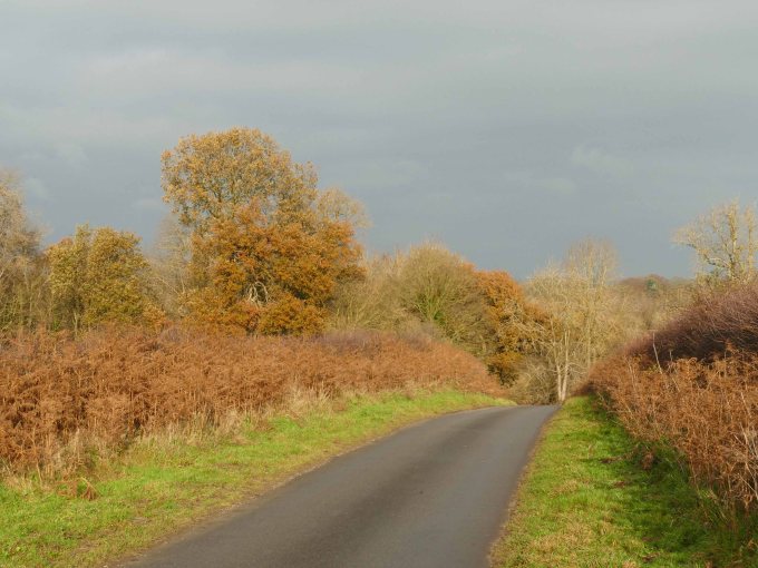
To travel this route from Greetham go north along Long Hedge Lane. At the crossroads turn right for Tetford but after a kilometre turn right again for Ashby. This is a narrow winding road that crosses a dry sandstone plateau trying to avoid the wet clay valleys which surround it. This is typical of Lower Lymndale where all settlement is also restricted to the dry sandstone either side of the river and roads cross it where the wet clay is narrowest. This has changed little since the Romans and probably well before them. There is plenty of evidence from aerial photography to show that back then this was one of the more heavily settled areas of the Wolds evidenced by the number of crop marks revealing tracks and settlements often only slightly off set from the present network of lanes and villages.
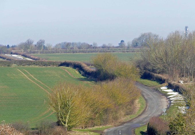
On the far side of the dale is Brinkhill Rigg whose tree fringed profile juts into the dale like the prow of a ship. Along the length of this ridge is an ancient road, probably an old salt way, which stretches back towards the coast via the ancient Hub near Ulceby Cross. If the line of this road is projected across Lower Lymndale it would cross the River Lymn just beyond Tennyson’s birthplace where there is now a small bridge built when Alfred was still a boy. An ancient road crossing the river at this point before continuing on to Horncastle would make a lot of sense because both the river and its valley are relatively narrow at this point. From here however it becomes a meandering lane that after crossing a second similar bridge climbs steeply back onto the sandstone plateau. It avoids the surprisingly rugged but diminutive dale of Snake Holes Beck by looping south but then by passes the quiet cul-de-sac villages of Stainsby and Ashby Puerorum continuing its meandering way to finally merge with the Tetford Road. Such is the winding nature of this road, which seems to avoid both valleys and villages, it can appropriately be called Snake Lane.

Where the route from the coast drops down steeply off Brinkhill Rigg it follows roughly the route of the green lane which now connects Brinkhill with Bag Enderby but on early OS maps it continued on to Somersby. This was abandoned as the main road inland sometime during the medieval period when wheeled vehicles took over from pack horses as the main mode of transport. This would have coincided with the gradual demise of salt production along the coast.
The sandstone overtime would have been worn down by horses and carts and have been rerouted many times as it became badly rutted unless there was no opportunity to do this. In such places centuries of traffic would wear the land down creating a hollow way. The approach to the ford over the Lymn just past Somersby, which was the best available ford in the lower dale, would be just such a place. Now and even when Tennyson was born in the rectory and baptised across in what was then a thatched church the road passed between them and is worn down beneath the general level of the land as it heads on down to cross the infant River Lymn.
The choice for crossing the river at this point was both it, and the damp valley it lies in, were narrowest here and it is before its first main tributary joins to double its size. A little further on this beck too had to be crossed and is in fact the original River Lymn before the waters for Upper Lymndale were diverted south during the last glacial maximum. Even today at Biscathorpe, in the centre of the Wolds, the River Bain is forded close to a church and its main tributary is also forded soon after. This is in the neighbouring wapentake of Louthesk and the road carries on to Gayton, which was also an important soke whose influence stretched to the coast similar to that of Greetham.
From the ford west of Somersby we are now on Snake Lane which quickly ascends back onto sandstone where it again have room to find the least obstructed route as it meanders passed Ashby. It then passes the ancient Holbeck quarries, where the stone for the Roman walls of Horncastle was thought to have originated just a mile north of Greetham, and there would certainly have been a need for a road on which to transport it to the newly fortified town.
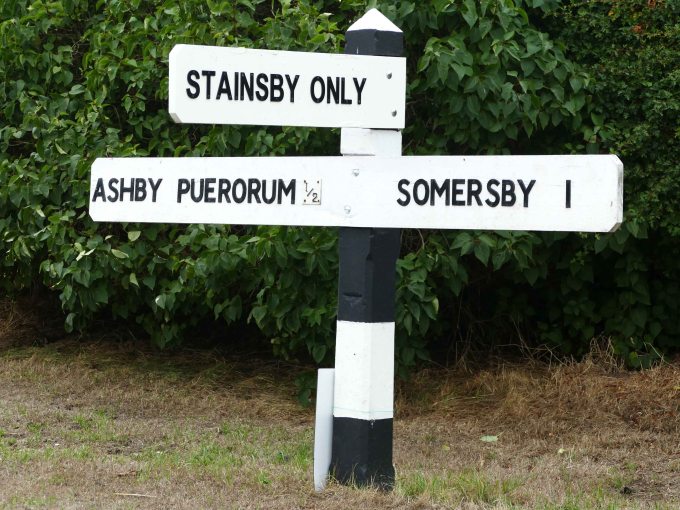
It also by passes Stainsby hidden at the end of a lane. Once a village you will now find just a large farmhouse surrounded by other farm buildings but just beyond once stood a Bronze Age round barrow from which a number of ancient stone and bronze artefacts where discovered when excavated in the 1950s. The site has now been ploughed up but is still worth visiting because of its commanding position which offers wide views across and down the dale to Sausthorpe steeple. To the north of the farm there are also good views across the river to Somersby and Bag Enderby.

In recent centuries there has been no single lord dominating Lower Lymndale also no turnpike roads were built crossing the area. This means that there is less chance of fundamental changes to overall road patterns in the dale as compared for example with the vast Yarborough estate in Lindsey’s North Riding. There roads, especially on the Wolds, stand out as being exceptionally straight except where the original east west road across the landscaped parkland was rerouted. Ancient roads, even Roman ones, are never so straight unless having been improved in modern times. In Lymndale the pattern of settlement during the Roman period was only slightly off set from the Anglo-Danish pattern or even present day settlements. This would suggest that here although modern roads and green lanes are now set their meandering routes will not be far removed from ancient tracks or medieval lanes. It is possible that even if he went back to the Roman period Tennyson would still see a basic familiarity to the landscape to that of his youth. There would be villages and farms in similar places spread out across the sandstone plateau connected by tracks shaded by spreading oaks. Below the constant river and its streams would be unchanged flowing passed alder, willow and lime and the ageless hills would be grazed by sheep.
Ashby Puerorum.

Ashby for a tiny village has quite a large church for these parts and it stands in splendid isolation overlooking an empty dale and is clearly visible from the coast road (A 158) on the ridge to the south. It is certainly larger than the church at Hagworthingham, a growing village strung out along the A158. Although it might have been Ashby’s association with Lincoln cathedral that determined its church’s size because the origin for puerorum being added to its name (A common occurrence because of the many Ashby villages in the area.) is that the parish provided a living for the cathedral’s choirboys. In the DB both were sizeable settlements with Hagworthingham for a time having quite a large church before it collapsed with today’s church much reduced in size from its medieval predecessor. Yet the two villages were never connected by a direct road.

As with neighbouring Stainsby, Ashby is also set back from Snake Lane and both stand isolated on the edge of the plateau with no roads crossing the beck to the south to link up with the busy present day coast road passing through Hagworthingham. Although there are several rights of way to be able to discover this dale, its beck is not crossed by a road along its whole length from Greetham to Stockwith Mill where it joins the River Lymn. This is because the dale it flows through was mostly damp and difficult to cross. Now the beck and its many tributaries could provide a useful network of carr corridors for wildlife passing from one small wood to another. In fact it is possible for a creature to travel all the way from Greetham to South Ormsby and only pass over one narrow road near Bag Enderby. Even Snake Lane winding from Ashby to Somersby is in such bad repair and seldom used that it is barely a threat to wildlife. Protecting or even enhancing this still unspoilt landscape would allow greater connectivity for wildlife in the heart of Hill Wapentake from Salmonby along its beck and then the River Lymn all the way to Stockwith Mill.

There is a track which runs down to the beck from close to Ashby church and where it crosses the stream, although improved, the land is still water logged and there are remnants of the natural flora such as buttercups, ladies smock and tussock grass beside both the track and stream. This would once have covered a wide area and probably included many more wild flowers such as common spotted orchid and ragged robin. The track then leads up to the coast road on the ridge (A158) which marks the southern edge of the Wolds AONB but beyond is Snipe Dales nature reserve, lying just within Hill Wapentake. This occupies a similar damp dale where the natural habitat has been preserved more like it was in Tennyson’s time. This is a good place to hear some of the birds familiar to the bard who benefit from the richer insect life resulting from a more mixed habitat of woodland and permanent pasture. Unfortunately it has not been enough to reverse the general decline of wildlife despite the best efforts of the wildlife trust to extend this small network of carr corridors as far as Hagworthingham. This linking of habitats should also be encouraged within the AONB using the natural connectivity of carr corridors, together with traditional meadows, as a framework to allow wildlife to spread from core areas where they hang on in isolation. Since Tennyson’s time the corncrake and turtle dove have disappeared, cuckoos and snipe are becoming scarce and skylarks, yellow hammers and other song birds are also less numerous.
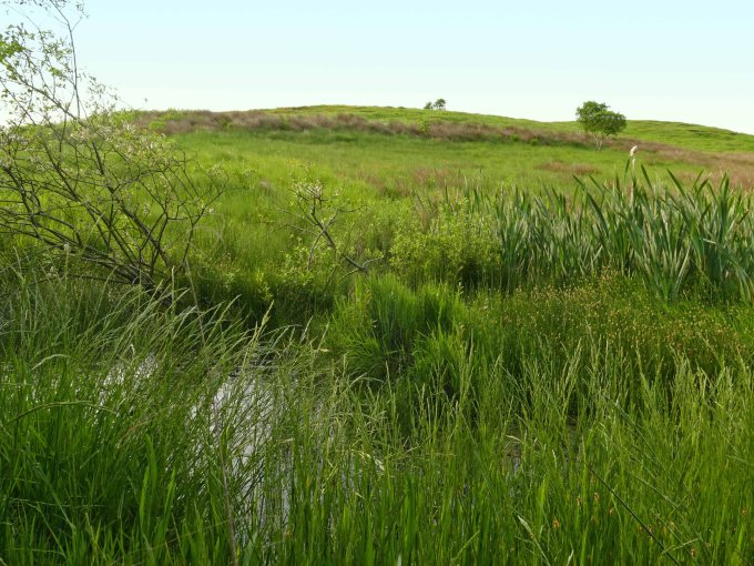
The main reason for this loss is the intensification of agriculture causing widespread loss of habitat. The amount of woodland in Lincolnshire has remained relatively stable over the last two hundred years although there was a big switch from native deciduous woods to conifer plantations during the twentieth century. By far the biggest loss of habitat though is permanent pasture and meadows in particular. It is thought that today there is just 142 hectares of meadow left in the whole of Lincolnshire (Lincolnshire Wildlife Trust 2000). We know at the time of the DB that Lymndale alone had roughly this much meadow and just the parish of Ashby had 12 hectares. These would have been in the valleys, mostly on clay and close to the river or its tributaries. In effect it filled the gaps between the strips of carr and therefore if reinstated would reconnect these wildlife corridors.
Apart from the benefit to wildlife the extension of carr corridors and the re-establishing of valley meadows with streams and the River Lymn allowed to meander naturally through them would lessen the chances of a re-occurrence of the flooding of the River Steeping near Wainfleet (June 2019). Lymndale is the main catchment area for the River Steeping and a move away from modern farming methods and a naturalising of the dale landscape would help the land retain water instead of it pouring out onto the flat fenlands and breeching dykes.

