Outside the Lincolnshire Wolds AONB the prominent ridge of sandstone stretching east to Spilsby and lying between the A 158 and A 155 still has some of the Wolds most attractive landscape including Snipe Dales and many pretty villages south of the B 1195. These have a number of hilltop churches overlooking valleys that contain remains of the last watermills of the Wolds before their fast flowing streams spill out onto the flat expanse of East Fen.
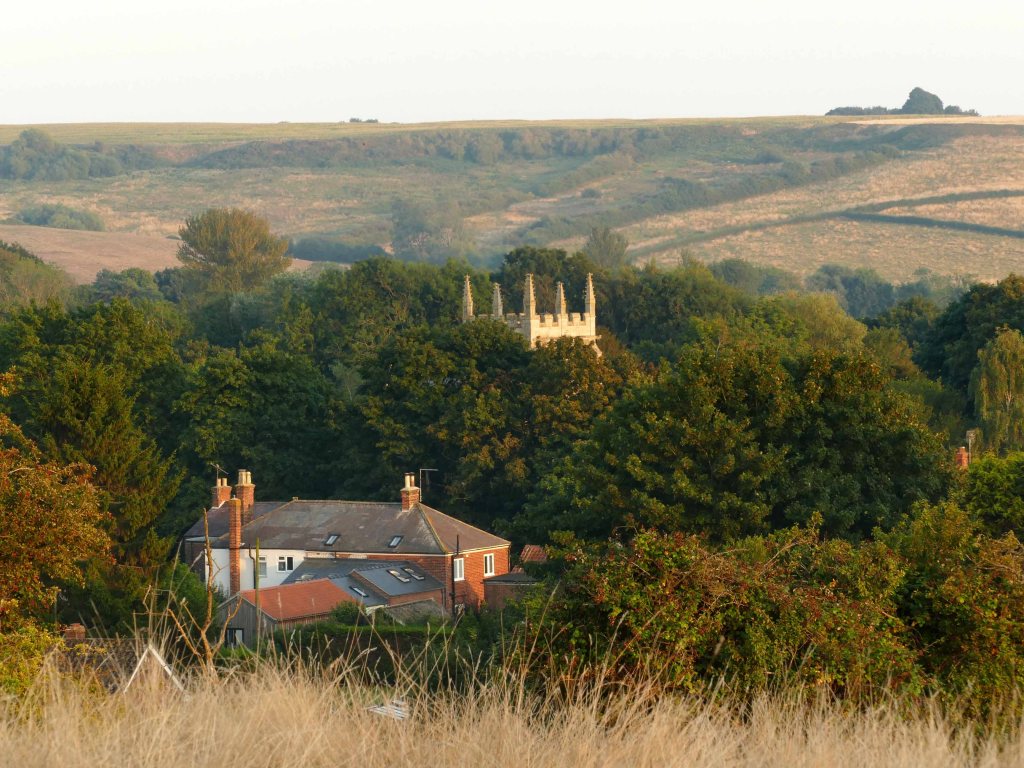
Despite being split by the busy A 16 this area has many lanes and footpaths that provide some of the best walking and views in the Lincolnshire Wolds. This includes around Old Bolingbroke which is heavy with history and stands in a wide valley sheltered by hills to the north. The sandstone from these hills was used by the Duke of Lancaster to build the castle and church in the fourteenth century. Both remain but much reduced in size as a result of the vagaries of time, not least the English Civil War when the buildings were occupied by opposing sides.
Immediately north of the village is Sow Dale. At two kilometres long stretching north almost to the B1195 ridge road, the dale is now partly owned and managed by the Lincolnshire Wildlife Trust (LWT). Until the early 1980s the dale had survived in traditional usage of meadow, pasture and woodland, but recently more intensive farming has converted areas of it to arable, with consequent loss of landscape and wildlife interest.
Further east the A 16 south of Spilsby curves westward towards East Keal with its large church standing proud on the southern edge of the sandstone ridge. Set on the last high ground of the wolds before the land abruptly drops down to the flat and intensively farmed Fens. On the north side of the road before reaching East Keal is the LWT’s Keal Carr Nature Reserve. This is the last wild wet valley to emerge from the heavily dissected sandstone plateau that extends back northwest all the way to Tetford and from which numerous streams flow into the River Lymn many of which are associated with other smaller carrs. (See the following post.)

The main road passes right by the reserve contained in a narrow steep-sided valley, although you wouldn’t notice as the road itself only dips slightly. On the south side of the road, but also hidden from it, the valley becomes deeper and wider and is overlooked by East Keal and Toynton All Saints, both of which stand on sandstone outliers overlooking East Fen. This flat expanse of waterlogged land was once famed for its abundance of eels and wildfowl but now drained and tamed it produces prodigious crop yields. Tamed however is the last word you would use for Keal Carr Reserve, which is not easy to access or penetrate unless you follow the Lincolnshire Wildlife Trust’s directions on its excellent website. https://www.lincstrust.org.uk/nature-reserves

Keal Carr, despite being found on the edge of the Wolds, is one of this area’s best examples of wet woodland made up mainly of willow and alder. Being a good six kilometres south of the main Wolds escarpment topped with chalk makes the geology much simpler and its features plainer and easier to read. The high ground of this southern extension of the Wolds is mostly made up of a wide plateau of Spilsby Sandstone and the valley of Keal Carr cuts deep into this from the south. It is a feature that can be seen clearly on a map but not so from ground level.

The day I visited was cool and grey with a stiff breeze blowing in off the sea. It was the end of summer and the ground was dry and unyielding with the surrounding fields being mainly stubble. To get to the one access point to Keal Carr Nature Reserve meant starting by the busy A16 and crossing one of the stubble fields and walking directly into the cool stiff breeze. The ground was hard and uneven and the line of the nature reserve sunken into the landscape was only barely visible ahead as a long line of treetops breaking the otherwise flat horizon.
It was a relief to reach the edge of the reserve, which is also an area of Site of Special Scientific Interest (SSSI) as a small plaque tells you as you enter the cover of the trees. The reserve is less than a kilometre long, varying in width between 150 and 250 metres in a valley no more than ten metres deep. (There is a narrow westerly extension of 500 metres to the reserve which tapers down to 50 metres in width making the total area of the site 12 hectares) On entering the reserve the contrast to crossing the bare windswept field could not have been greater. You could say it was like entering a different world if it had been on a larger scale but it was certainly a totally different habitat ruled over by a lush green growth of plants that relish damp conditions. There was a wide range of species occupying the understorey, many of them like the wild angelica were at least chest high. This, however, and the boggy ground makes much of the reserve inaccessible although fortunately a right of way has been cut across it. This too would have been a challenge if the Wildlife Trust had not put in place steps down the steep slope to the valley floor along with a wooden causeway to cross the boggy valley bottom, which ranged from spongy to a thick black ooze consistency.

The reserve is essentially a classic carr wood filled with mainly alder and a few other species like hazel and willow and the forest floor is covered with species that can tolerate the damp conditions with thick clumps of giant marestail where the conditions are wettest. The conditions on my walk had not only changed radically underfoot but also the atmosphere felt quite different from when crossing the exposed field to get here. The wind had gone and the air was humid making it feel noticeably warmer. The length of the carr is crossed by a stream that collects enough water issuing out of the valley sides where the porous sandstone meets the impervious clay that only one kilometre downstream its flow was sufficient to power the Wolds most southerly watermill back in Tennyson’s day.
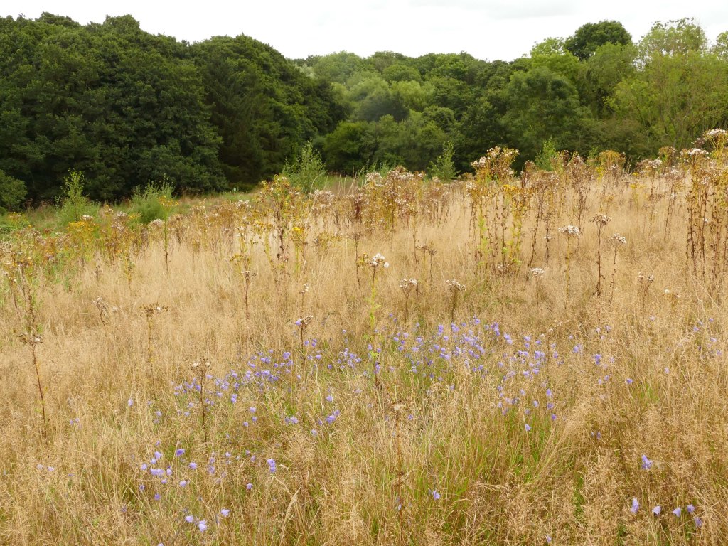
The journey across Keal Carr was brief but memorable because after crossing the stream the path leaves the wood and climbs up the hill back onto the sandstone plateau which is again a complete contrast to conditions in the carr. The path takes you through unimproved pasture which on reaching the top of the hill was covered with flora that thrives in dry conditions like pale blue harebells that were nodding in the cool breeze, which had returned to keep me company for the last leg of my walk. This required following a path around the top of the long narrow western extension to the reserve. Once past some derelict buildings and a house (Glebe Farm) I took a left turn on a path that led back to the road. This though first dipped down into the now shallow valley but still meant avoiding the boggy valley bottom where rain that had fallen on nearby Mardon Hill (92 m. above fen level) remerged to form the beginning of the stream flowing through the carr. On climbing out the little valley up to a stile brought me back onto sandstone which was evident in a small outcrop of rock nearby the stile. From there it was back across the exposed plateau to the road. The half-hidden valley of Keal Carr nestling in a narrow break in the plateau quickly receded from sight but the experience of diving down into its hidden world of luxurious growth stayed with me for some time.

This is the most southerly and relatively isolated of the Carr Dales but there are many more narrow wild wet valleys in the Wolds mainly clustered around Lymndale. Many are hidden or difficult to access but all are responsible for providing greater habitat and wildlife diversity to the Wolds, which is explored more comprehensively in my next two posts Wolds Wet Wolds Wild Carrs.
