The A 157 road from Lincoln to Louth is an attractive route to cross the Wolds and the climax to this is crossing Grim’s Mound Rigg just east of Burgh on Bain. This north-south ridge climaxes just north of the road at Grim’s Mound described by the Heritage Gateway thus – the earthwork remains of a bowl barrow known as Grim’s Mound is located in a commanding position on the summit of a spur between the River Bain and one of its tributaries. It is a grassy mound some nineteen metres in diameter and 2.6 metres high, situated adjacent to the Viking way which runs between the sites of the mediaeval villages of Biscathorpe and Calcethorpe. (Heritage Gateway)

From this commanding position it is possible to view much of the Bain Basin which lies between the two ridgeways of Caistor High Street and Bluestone Heath Road and takes in all the many small streams that flow down narrow valleys to all ultimately come together in the hamlet of Biscathorpe. The two main tributaries that for a time flow south almost parallel on either side of the ridge are Ludford Beck and Kelstern Beck. Each is named after the settlements closest to their sources and Viking Way Long Distance footpath (LDP) uses much of the ridge for three kilometres to head south between them. North of Grim’s Mound the ridge is an extension of the open and mainly arable chalk plateau that dominates the central section of the Wolds but south of the barrow the ridge descends gently down to the valley bottom where the two becks merge to become the River Bain. It is this section of the LDP that passes through the mediaeval parish of Biscathorpe and is interesting as it passes through several different historic landscapes and habitats.


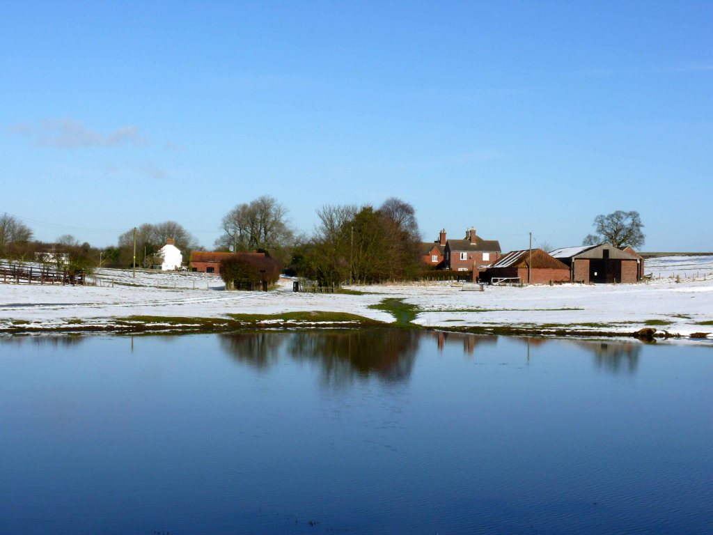
At the very beginning of this blog (April 2018), I wrote a post about Monksthorpe Chapel, a National Trust property on the edge of the Fens, and described how this quiet corner of Lindsey had once been a busier place. This too can be said of Biscathorpe hidden between hills and only accessed by narrow lanes. Most of the buildings that make up this hamlet are scattered and hidden by trees. There is Biscathorpe House set in its park and remarkably the church survives with only its mini spire peeping out from an envelopment of trees, mainly yews. It only has Church Cottage for company, which is now a holiday let. The original village is no more and has been long abandoned but is marked on OS maps and is the hummocky ground on the south-facing slope north of Ludford Beck. North of this there is a large area of trees, shrubs and the occasional pond. This was once an area of sand and gravel workings that was still active in my lifetime and covered an area stretching between the two south flowing becks which meet close by the church.

The sand and gravel that were excavated covered much of the surrounding land of the original parish of Biscathorpe and were fluvioglacial deposits or outwash sands left by an ice age hundreds of thousands of years ago and immediately to the north crossing the Wolds from west to east is a thick deposit of glacial till that marks the probable moraine from out of which the sediment choked meltwater flowed. Just beneath these two sets of glacial deposits is a fairly complex geology similar to that found in Lymndale. (See The Geology of Lower Lymndale post.) Here however there is much more chalk which caps most of the surrounding hills and a lot less Kimmeridge clay that only makes an appearance south of Biscathorpe.
The chalk is significant in that it is the main aquifer that feeds nearly all of the River Bain’s many tributaries north of Biscathorpe making them all true chalk streams and the River Bain a proper chalk river. One of only a few north of the Wash. Although the River Bain is usually regarded as having its source just west of Ludford for the purposes of this post I have chosen to call this branch of the river Ludford Beck which flows past Burgh on Bain and eventually merges with a stream of equal size at Biscathorpe by the church. I have called this other stream Kelstern Beck and only refer to the River Bain as the combined waters of the two becks downstream from their confluence.

The fact that the River Bain only cuts down to Kimmeridge Clay south of Biscathorpe in my mind makes it a better candidate for being the inspiration for Tennyson’s The Brook (See The Brook post) than the River Lymn whose course flows almost entirely through a clay vale making it sedate and meandering except for where it passes through Tetford as a small stream. The Bain also fits in with some other descriptive details like flowing into “the Brimming river” of the River Witham but the most significant line is where Tennyson writes how it flows by “twenty thorpes”. The upper reaches of the Bain and its tributaries abound with these types of settlements.
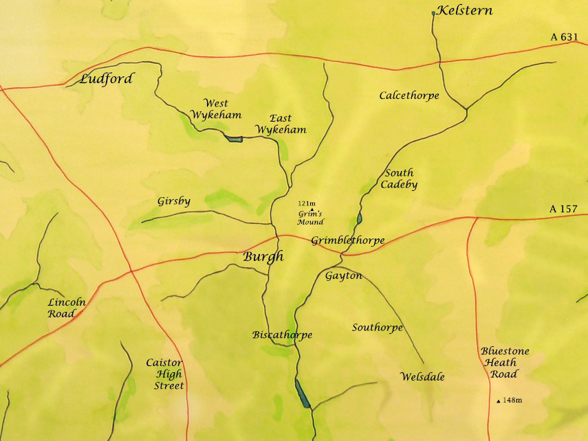
The word thorpe is originally Danish and is most frequently associated with a small secondary settlement. The Danes settled in large numbers across Lindsey and particularly in the Wolds and a thousand years ago the upper Bain Basin was more heavily settled than it is now. Like with Biscathorpe many of these settlements were eventually abandoned. Some had the suffix thorpe but most were by definition thorpes and on the map they have all been included but written in a slightly smaller font than the larger villages. Yet at the time of the Domesday Book Girsby and Gayton were the most populous villages and Burgh was an abandoned settlement.

In the case of the abandoned settlements, their demise was partly brought about by a shift away from mixed farming on the Wolds to mainly sheep rearing that required a lot less labour. In the last two hundred years with the aid of machinery and chemical fertilisers the emphasis now has switched to predominantly arable farming, especially on the chalk wolds to the north and east of Biscathorpe.
The original acreage of the parish of Biscathorpe was tiny, as were many of the parishes in the Bain Basin even into the nineteenth century, but the land is varied stretching down from Caistor High Street to the River Bain. However, the most significant part of the parish stretches from north to south across the parish between the two becks and onto the southern border of the parish with Donington. Due to a set of fortunate circumstances over a number of centuries here there remains a diversity of land use that is now more conducive to wildlife than much of the central Wolds .

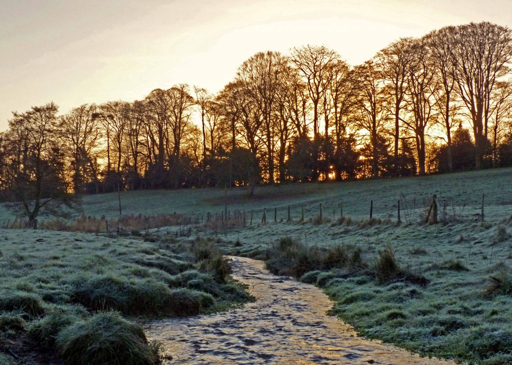
Starting from the northern boundary of the old parish, there are the old sand and gravel workings that have been quickly reclaimed by nature into a mix of scrub and woodland dotted with ponds. Continuing south the landscape would have changed greatly from Tennyson’s day if he ever passed this way when travelling from his home in Somersby to Tealby, where his uncle lived, or Grasby, where his brother was rector. The hummocky ground here marks out the site of the long lost mediaeval village on the land sloping down to the beck which would have probably been grazed then as it is now. At the foot of the hill the Ludford Beck still runs clear, hurrying along to merge with the waters of Kelstern Beck but the original OS map for the area, from 200 years ago, shows a small nuclear village just south of Ludford Beck with two roads approaching it from the west, one via Biscathorpe Plantation and the other from the southwest. Most remarkably is that in between these two lost lanes a whole hill has also disappeared as a result of gravel workings in the twentieth century. as shown in the map below.

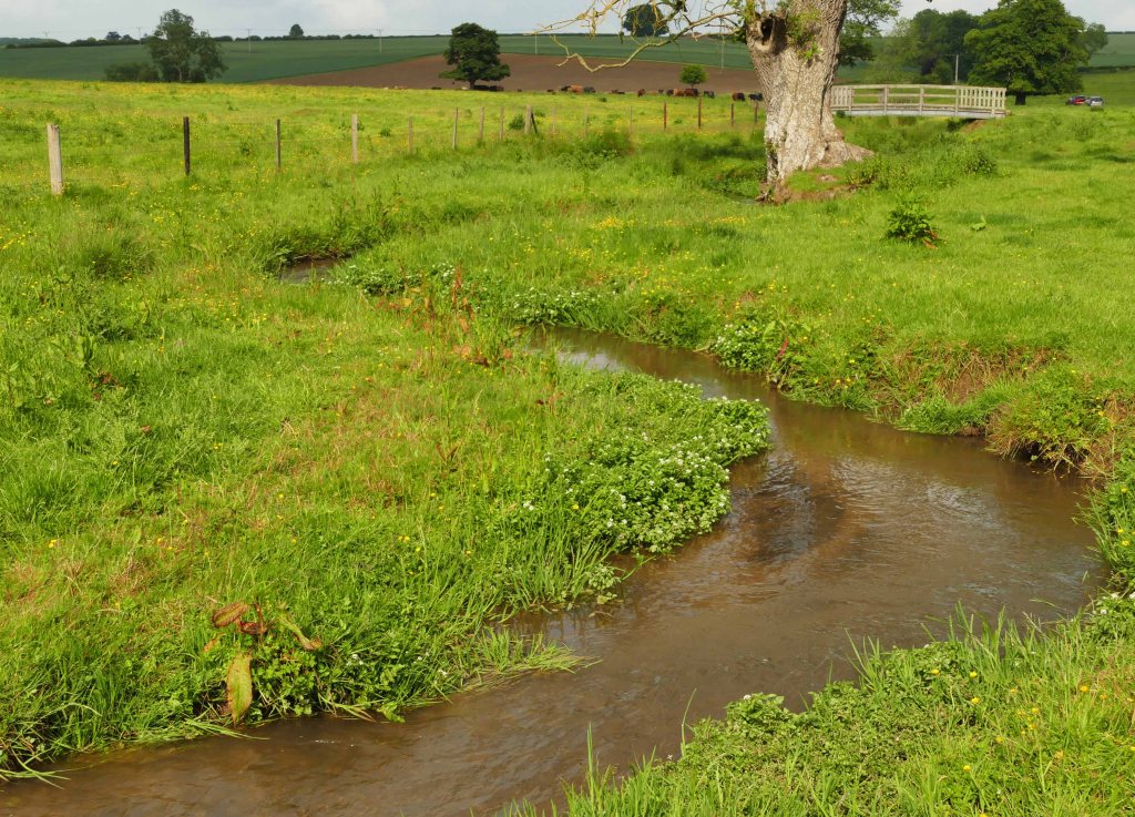
Today the two becks merge into the River Bain which meanders more serenely past the little church of St Helen’s. This was rebuilt in 1847 but back when Tennyson was young it was likely to have had no spire and a thatched or possibly tiled roof. Upstream as shown on the map the two becks have sections where they still meander in tight loops before straightening on approaching Biscathorpe. Whether this straightening was done by Tennyson’s day, as was the case with Ludford Beck around Burgh Mill a little further upstream, is not clear but it would be good to return the becks to a more natural course within the parish and is also more in keeping with the river’s natural course downstream of Donington. (See below.)
Crossing over Ludford Beck to the south the land rises steeply capped by a plantation of tall trees; the two create long shadows in winter adding to the tendency for frost and mist to linger in the valley bottom. On the high ground beyond stands the nineteenth century Biscathorpe House from which its associated park stretches south for half a kilometre and east down to the lake. The park contains several mature oaks mostly close to the road. The prospect from the front of the house across the park is a fine one and extends over the valley across to the steep scarp slope of the Wolds where it rises to eighty metres above the river. The house stands beside the road which cuts through the parish from north to south while across from the house the land falls away steeply where there had been earlier sand and gravel workings (see above) but this is now hidden with the depression having been replanted with trees.

The total area described above is one kilometre long by half a kilometre wide or roughly 50 hectares creating an island of biodiversity that sits in a wider landscape that is mostly dominated by large, intensively farmed arable fields offering little sanctuary to wildlife. The Viking Way cuts diagonally across this quadrant. The LDP having left the open chalk uplands behind on crossing the A 157 follows the first part of the narrow lane just described south along a ridge with views across to Burgh. Descending gradually towards Biscathorpe after about half a mile the Viking Way is crossed by a footpath linking Burgh to Gayton. From here there are the abandoned workings to the left, evidenced by the uneven terrain covered in trees and shrubs. Access to this landscape and a small lake is possible by following the footpath to Gayton.
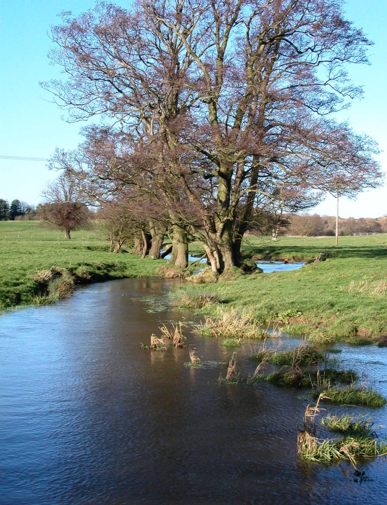
Ahead the lane continues down to Ludford Beck but the Viking Way holds the high ground by veering off left through a small wood and soon emerges out onto grassland with views over the valley across to St. Helen’s diminutive spire nestled in the valley with the Gartree Hills rising behind in the distance. Immediately ahead though lies the deserted mediaeval village of Biscathorpe with only uneven ground betraying its presence but this is enough for it to have escaped ever being ploughed. The Viking Way passes over this ground and heads down to Luford Beck which it crosses before heading on past St. Helen’s. It then cuts across a corner of Biscathorpe Park before crossing the River Bain just downstream from where Ludford and Kelstern Becks merge. From here the LDP heads on south first following the river and then along the east bank of the lake and on to Donington.

There is however the option to cross the valley from west to east following the little used road that heads for Gayton. From the junction with the main valley road, it heads west keeping close company with Ludford Beck which it eventually fords at West Ford and then just after a hundred metres it fords Kelstern Beck at East Ford. From here it climbs steadily out of the valley finally passing through a gate. Up to this point, it should be said, that the road has been open to the surrounding pasture land giving unhindered access to all the waterways it passes. Although from East Ford, on its south side, it does have the barrier of a small steam tumbling down the hill to merge with Kelstern Beck by East Ford. The waters of this beck then mix with those of Ludford Beck close to West Ford to become the River Bain which after only 500 metres flows into the lake.

All these features together provide many aspects of The Brook described so eloquently by Tennyson and which I am not going to attempt to emulate. So simply, from the fast flowing stream beside the road, Luford and Kelstern becks hurrying to merge and to then carry on as the mature meandering River Bain which itself soon enters the brimming lake brings together in close proximity many of the features of Tennyson’s Brook.
South of the lake the River Bain passes through Donington, the most northerly parish in the wapentake of Gartree, that both the River Bain and the Viking Way pass through. This part of the Bain Valley is remarkably similar to Lymndale. In both you find villages on the dry sandstone plateau overlooking the damp clay valley bottom along which the river takes a highly convoluted meandering course often hidden among damp tolerant trees. The river and LDP finally part ways where the Viking Way veers off over Colley Hill towards Goulceby and the Gartree Hills (See Gartree Hills and Tennyson Trial posts.) but the two eventually reunite in Horncastle. The river’s route is more hidden and lonely but can be accessed by a couple of paths and lanes which cross it.

“With many a curve my banks I fret” is how Tennyson describes the course of “The Brook ” and this also describes the mid-sections of both the Bain and the Lymn. Further downstream, however, the River Bain is first straightened by man and from Horncastle its waters are diverted into the Horncastle Canal. Now disused it still takes the waters of the Bain south to empty into the brimming waters of the River Witham near Tattershall; as is described in Tennyson’s poem. The waters of the River Lymn meanwhile on leaving the Wolds are diverted into the Steeping River, a straight line cut across the Fen to Wainfleet Haven well away from the River Lymn’s original course.

There is however a much less quoted poem that the bard wrote, possibly because it was written in Lincolnshire dialect, called the Northern Farmer which refers to Wrigglesby Beck. This name is descriptive and alludes wonderfully to the natural winding nature of both the Bain and Lymn along quiet sections of their middle courses through the soft damp and easily eroded clay valley bottoms, so I have let Tennyson say the last words.
Looök thou theer wheer Wrigglesby beck cooms out by the ‘ill!
Feyther run oop to the farm, an’ I runs oop to the mill;
An’ I ‘ll run oop to the brig, an’ that thou ‘ll live to see;
And if thou marries a good un I ‘ll leäve the land to thee.
Thim’s my noätions, Sammy, wheerby I means to stick;
But if thou marries a bad un, I ‘ll leäve the land to Dick.–
Coom oop, proputty, proputty–that’s what I ‘ears ‘im saäy–
Proputty, proputty, proputty–canter an’ canter awaäy.