Overview
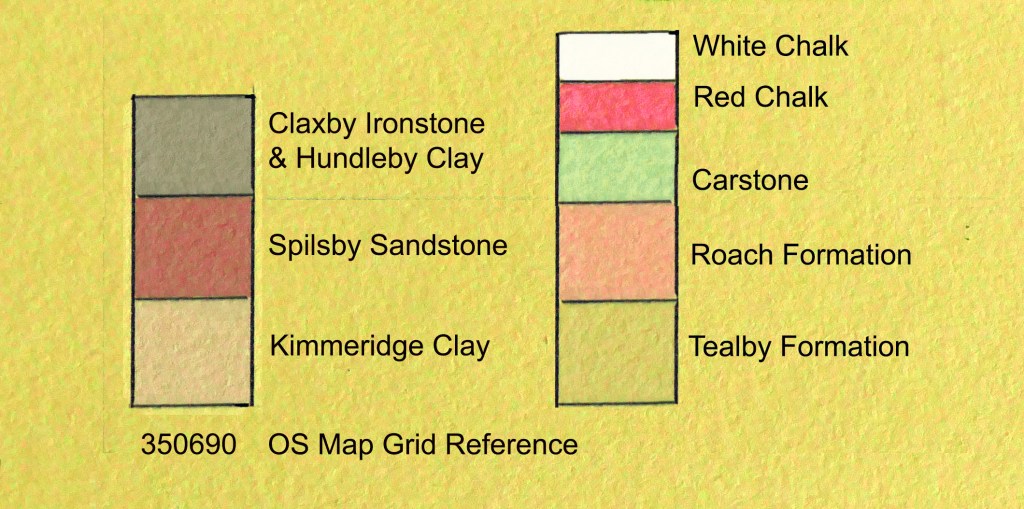
The following series of profiles are cross-sections of Snipe Dales and its beck down to and including the River Lymn. They show how although the band of Spilsby Sandstone is only around ten metres thick, with it dipping gently from southwest to northeast, it continues the length of the dale from Winceby to Sausthorpe where even then it continues as a plateau right up to the base of Langton Edge. This combination of geography and geology allows this narrow band of porous rock to impose its influence on much of the South Wolds especially with it overlaying a thick impermeable layer of Kimmeridge Clay creating a long and incised spring line between the dry plateau overlying the damp clay valleys. This produces a landscape of many small streams, often emerging in boggy depressions overlooked by scrubby bands of gorse, flowing into the meandering Snipe Dales Beck hidden among alders overlooked by hamlets with small sandstone churches. (See The Distribution and Geology of the Carr Dales post.)
All profiles are diagonals bisecting a square in the Ordnance Survey grid making each 1400 metres long.
Winceby 320680 – 330690

This cross-section at the top end of the dale actually begins on Claxby Ironstone, a band of rock that overlies the Spilsby Sandstone and continues east to Lusby and reoccurs near Mavis Enderby. The small feeder streams of Snipe Dales Beck emerge east of the profile, just 500 metres upstream, and have already cut deep into the clay. Part of this profile follows close to a footpath giving access to the nature reserve and the dale bottom. (See A White Snipe Dales post.)
Snipe Dales Country Park 330690 – 340680
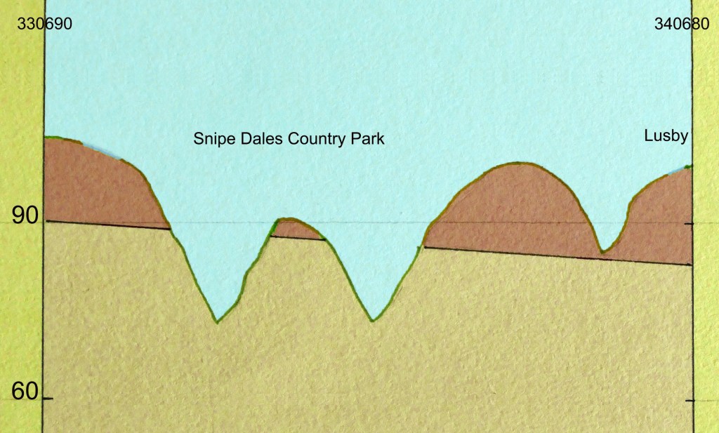
Here this diagonal crosses back over the dale by a particularly undulating line crossing three narrow valleys in just over a kilometre ending up close to Lusby. The first two valleys are accessible as they are part of Snipe Dales Country Park and the third is visible from the footpath that follows Snipe Dales Beck from the park east to Lusby Lane. The profile finishes near the top of the hill and edge of the village.
Lusby Lane 340680 – 350690

This profile heads northeast back across the dale with the first half closely following Lusby Lane downhill from the edge of Lusby. This narrow hollow way cuts into the sandstone and is enclosed by a canopy of trees and tall hedges before bending away from the diagonal and crossing the beck by a ford to enter Hagworthingham. Meanwhile, the diagonal line heads towards the steep shaggy profile of Furze Hill nature reserve overlooking Snipe Dales Beck. (See crossing Lymndale by Car post.)
Furze Hill 350690 – 360680

Furze Hill is just over 60 metres asl overlooking the beck twenty metres below but this modest spur of sandstone still offers extensive views across the dale back up to Snipe Dales Country Park, back across the dale to Lusby and also down the dale. This is partly because there is a break in the sandstone ridge north of the beck and the widening of the dale to the south of it. This also means that this profile is much more gentle but if the line is continued into the following square here slopes steepen again crossing Milelong Dale.
(See Traversing Lower Lymndale post.)
Milelong Dale 360680 – 370670
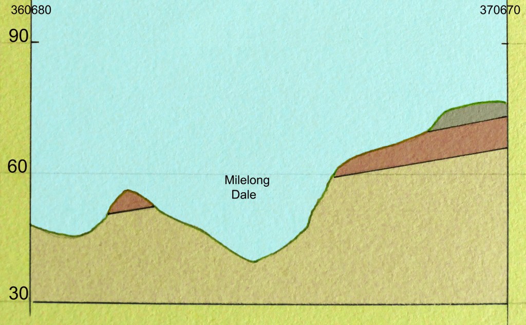
This dale is not accessible and mostly hidden by woods clinging to steep slopes, some are SSSIs as this was always the most wooded part of the Snipe Dales Beck catchment. However, there is a footpath connecting Hagworthingham and Mavis Enderby that overlooks it and crosses Milelong Beck before it makes a final steep boggy climb up to Mavis Enderby church which overlooks the dale. The line of the profile, meanwhile, crosses the dale before climbing steeply up to nearly eighty metres asl where it meets Claxby Ironstone again together with some Tealby Formations. Close by is a footpath connecting Mavis Enderby with Raithby that offers impressive views right across Lower Lymndale as far as the bold escarpment of Langton Edge. (See Big Skies and Hidden Valleys post.)
Raithby Bridge 370680 – 360690

This starts a kilometre north of the viewpoint just described above. The profile this time trends southeast to northwest, and closely follows the road that crosses Snipe Dales Beck at Raithby Bridge. The beck has now grown after taking in the waters of Milelong Beck and many other streams. It now meanders lazily through the dale in big loops restricted only where it passes through the solid concrete bridge. Despite this and being close to entering the floodplain of the River Lymn the width of the dale has narrowed affording a drier route for the road to follow that connects Raithby with the main A 158 just beyond the end of the profile. This main road heads east to the coast and follows a Claxby Ironstone capped ridge before dropping down to cross the River Lymn. Close to the junction of Raithby Lane and the main road there are the best views to be had back up the dale. Also across the main road opposite a convenient lay-by there are views in the opposite direction (NE) across Lower Lymndale to Langton Edge.
Sausthorpe Bridge 370680 – 380690

At right angles to the base of the previous profile (GR 370680) this profile heads northeast towards Sausthorpe, ending 250 metres short of the busy A 158. Just short of Sausthorpe, set on a sandstone plateau forty metres asl with its landmark church, is the River Lymn twenty metres below. Sadly after having cut its own natural contorted course through the soft clay down the length of the dale the final last few hundred metres of Snipe Dales Beck have been brutally redirected to flow along the side of the road that leads to Sausthorpe Bridge, crossing the Lymn where the beck and the river meet.
(See The River Lymn & Its Tributaries post.)
Langton Edge 391701 – 401711

Continuing in the same northeasterly direction passing over the OS grid square that contains Sausthorpe and the attractive grounds of its hall the next diagonal follows the line which starts by Langton Beck, passes by Langon village and finally climbs the steep and wooded Langton Edge. This line keeps close company with the road that passes through the village and climbs the scarp slope just to the north. Langton is the last village set on the sandstone but from here there are half a dozen different types of strata before the land levels out on the chalk plateau ninety metres asl. The character of the land here changes from having been sheltered and wooded to dry open arable fields on gently rolling hills. (See Langon Old Road post.)
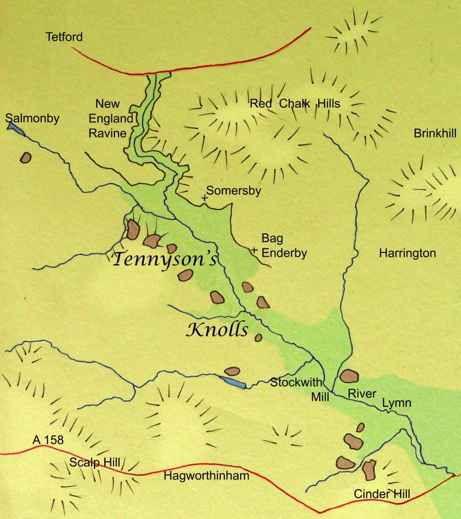
Bag Enderby 340710 – 350720

Five kilometres northwest of Sausthorpe, Bag Enderby stands on the same sandstone plateau just ten metres higher than Sausthorpe. It too overlooks the River Lymn but here the river is confined in a trench like valley just a few hundred metres in width. On the far side opposite Bag Enderby’s medieval church, there is a small sandstone topped hill. Beyond it, the land dips before rising gently up to another plateau of sandstone on which stands the tiny hamlet of Stainsby. (See Somersby & Bag Enderby post.)
The small isolated sandstone hill just referred to may be a subtle feature in the landscape but it is just one of a good number of similar hills, never much over sixty metres asl, which overlook the River Lymn stretching from Salmonby southeast as far as the A 158. The most prominent, however, are those that lie directly opposite Somersby and are immortalised in Tennyson’s most admired poem In Memoriam AHH. Here he remembers one benign summer’s evening looking across from the garden of the rectory, where he spent the majority of his first twenty eight years, and describes it thus –
While now we sang old songs that peal’d
From knoll to knoll, where, couch’d at ease,
The white kine glimmer’d, and the trees
Laid their dark arms about the field.
These knolls lined either side of the River Lymn are a legacy of the Last Glacial Maximum when for a time the River Lymn’s power was increased manyfold by the glacial meltwater from several blocked dales trying to escape the Wolds by a more southerly route. It is this torrent that cut the New England Ravine upstream from Somersby and the trench like valley that continues on to Stockwith Mill where the force of the water was finally dissipated when entering a temporary lake dammed by another glacier. (See New England Ravine & Warden Hill post and The River Lymn and its Tributaries post.)
During these periglacial conditions, permafrost gripped the land but when it finally thawed for a time the land would have been unstable causing episodes of solifluction along steeper slopes. This would have been the case on the steep-sided trench along which a more benign River Lymn now flows. Even subtle dips in the land which were most saturated when thawed would have slid into the valley bottom leaving the intervening high points as the knolls that Tennyson observed.
The Introduction to The River Lymn and its Tributaries post.
The small streams that come together to form the River Lymn run down from the hills west of Tetford. They pass through the village as a fast flowing stream which at this stage is the very epitome of Tennyson’s brook. Particularly just past Tetford watermill it babbles over rocks and roots as it hurries through the village but instead of carrying on east along a wide valley toward South Ormsby it takes a sharp right and enters the New England Ravine. This is because 20,000 years ago the main valley was blocked by ice. This then caused it to flood and the river to spill over a low ridge into the valley to the south and with the force of the meltwater from the glacier it cut a steep sided valley through the sandstone ridge down to the clay below. Beyond the ridge, this surge of water also gouged out a trench 500 metres wide in the soft clay all the way to Stockwith Mill before spilling out into another temporary glacial lake partly surrounding today’s village of Sausthorpe. This new course, which the river still occupies, is partly responsible for forming the prominent “knolls” that Tennyson refers to in his most acclaimed poem In Memoriam AHH. These, as described in his poem, are visible from the garden of the old rectory where he was born and lived for most of the first twenty eight years of his life. (See Tennyson’s Knolls post.)
